A journal of the thoughts, pictures, and adventures of photographer and writer Lee H. Rentz. Inspired by nature, with a passion for ideas both visual and literary.
Karen and I have encountered Black and Grizzly Bears occasionally, and these sometimes make for memorable stories. Here are five adventures that we can’t possibly forget, along with assorted bear photographs I’ve taken in recent years.
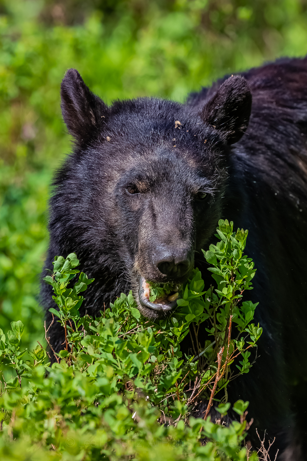
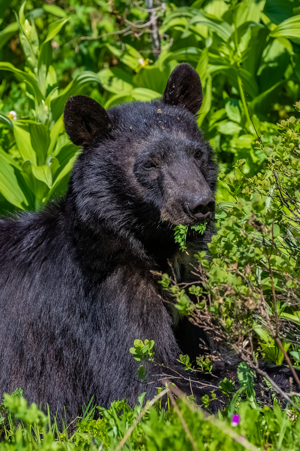
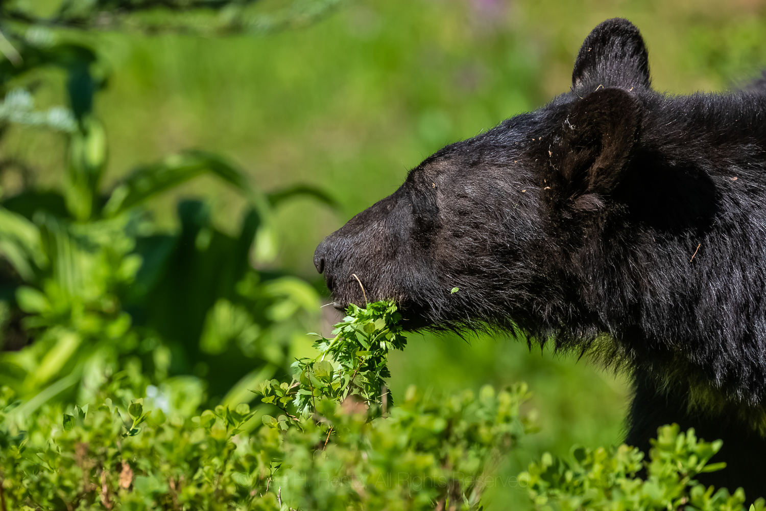
American Black Bear feeding on Gray’s Lovage in July, Mount Rainier National Park in Washington State
WATCHING BEARS AT THE DUMP
Copper Harbor on Michigan’s Keweenaw Peninsula, circa 1959
My family used to take camping vacations to state parks back in the 1950s and 1960s. Of those, Fort Wilkins State Park at the tip of Michigan’s Keweenaw Peninsula, which sticks up like a long curved finger into Lake Superior, was a favorite. This was an early army outpost established in 1844 to keep order during a copper boom in the region, and there were cannons and a fort that excited the small boy in me.
But the coolest thing we did as a family there was to drive the ’57 Chevrolet station wagon to the dump and wait until dark, lined up with all the other classic Detroit cars. At deep dusk the bears arrived one by one, until there were five. They poked their snouts into the fresh garbage and turned over cardboard boxes with their powerful legs and claws, each working independently of the others. I remember one was a big cinnamon-colored bear, while the others had black hair. I’m sure the dump smell and flies were awful, but it was thrilling to see bears up close for the first time in my life.
Dumps used to be a special way for families to experience bears outside each small town in the Upper Peninsula. Those days are long gone, but those of us who experienced bears at the night dumps will never forget the adventure. Here is a sampling of memories of that time by many people: https://www.pasty.com/discuss/messages/313/617.html
American Black Bear traversing in an alpine meadow on Sahale Arm, North Cascades National ParkAmerican Black Bear foraging in a Ponderosa Pine forest near the ghost town of Garnet, Montana, USA
SLEEPING WITH A BEAR
1982 in the High Peaks of the Adirondacks
We were camped in a dense stand of Red Spruce high in the mountains. We knew that there were bears in the mountains, so we hung our food, but we didn’t have the mental acuity or experience to hang the food correctly in a tight grove of toothpick trees.
An hour later, in the tent, we heard a dreaded sound outside. I opened the zipper, and of course it was a big American Black Bear of the bad boy kind. I startled it by poking my head out the opening, and the bear responded by immediately climbing a tall spruce within five feet of our tent. So, it was a standoff, with me looking nervously up at the bear and it looking nervously down at me, occasionally clacking its teeth to warn me how fierce he was.
The standoff lasted all night. I had finally fallen asleep and didn’t wake up until we heard the sound of claws descending on bark. We quickly got dressed and I assumed the bear had skedaddled away, but instead it went directed to our hanging food bag. I think the bear had gotten into the food before coming close to the tent the night before, and the torn bag waving in the breeze and a pile of plastic bags below told the story. We finally chased the bear away, but we were short on food the rest of the weekend trip. My morning ration of instant coffee had bear saliva on its torn plastic container, and we never did find the peanut butter.
In the years since then we have learned to engineer a relatively bear-proof hanging bag under most circumstances, but it is often a challenge that most hikers don’t master, based upon most of the hanging food bags we see. Bear spray is also a good idea, though I don’t normally carry it in Black Bear country.
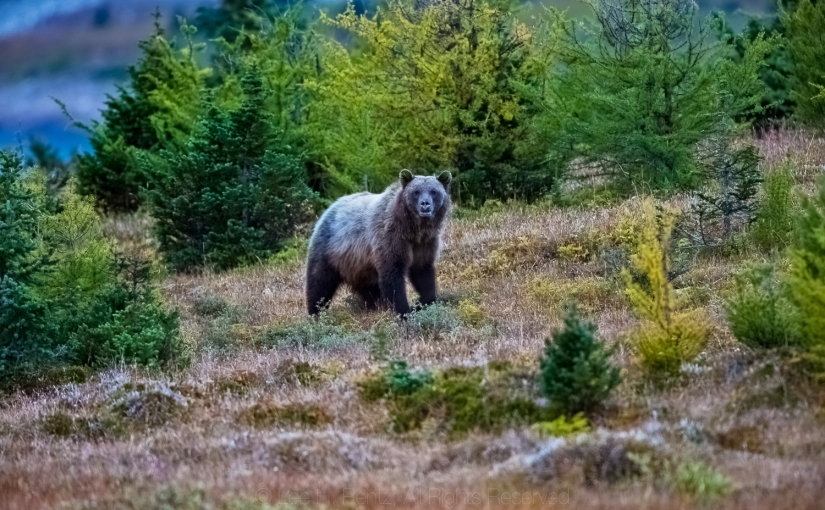
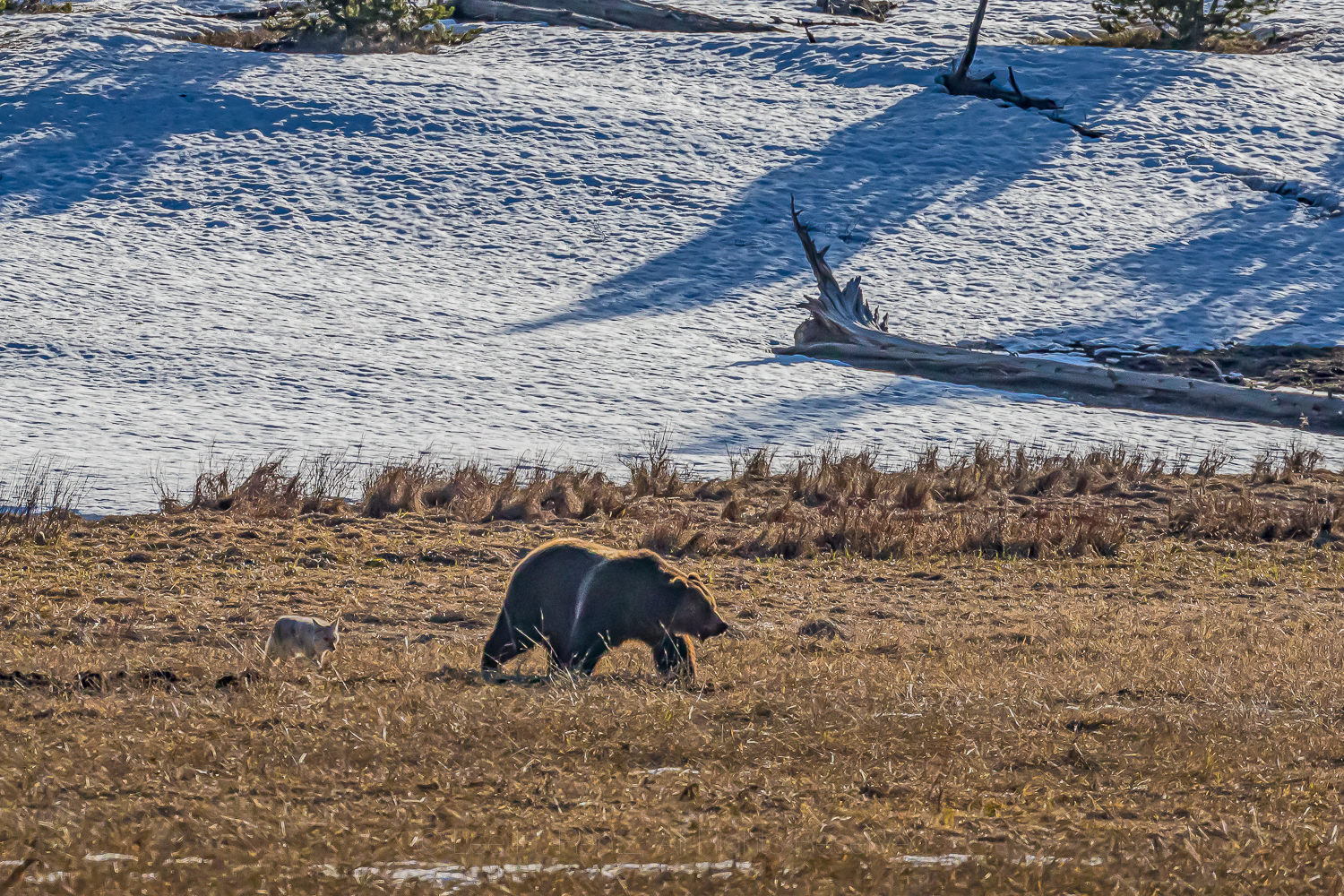
Grizzly Bear searching for food, accompanied by a scavenging Coyote, in Yellowstone National Park
FENDING OFF A BLACK BEAR WITH STONES
1989 in the Mount Baker Wilderness, Washington State
We left our rental car in the parking lot at the trail leading to Hannegan Pass to begin a backpacking adventure in North Cascades National Park. At the trailhead we had an unusual siting of a Black Bear wandering around, and in the trail register comments someone wrote “pesky bear!” We set out on our ten day backpack into lowering clouds.
We set up camp among blueberry bushes and conifers, cooked dinner and hung our food in two heavy bags from a tree branch, then retired to our tiny tent. The next morning, we got up and immediately found a Black Bear under our food hang, trying to get at it. I yelled at it and threw some stones to try and chase it away, and it left, But I had a feeling that it wasn’t done with harassing us, so I went to where I anticipated it might approach the bag next, and lo and behold, there it was! So I threw more stones, hoping to discourage it. After a couple more parries, the bear finally left us alone.
Later in the day however, as we were hiking, a bear descended a mountainside at an angle that would intersect with us, causing us to be really apprehensive about its intent. It came within 20 yards of us, and I suspect it was the same pesky bear, but we hiked beyond without incident. The rest of the trip was bear-free, but those first two days were more than a bit unnerving.
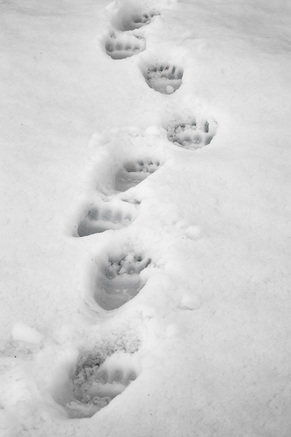
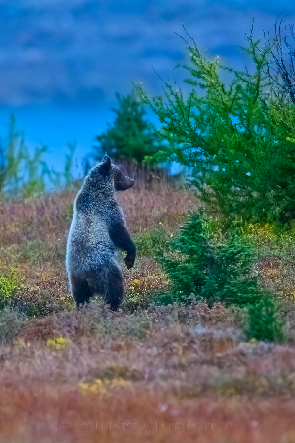
Tracks of Grizzly Bear 399, who was accompanied by her two cubs of that year in snow in Grand Teton National Park, Wyoming. She had been seen here five minutes before we came on the scene.
BEING BLUFF-CHARGED BY A BLACK BEAR
1991 in Enchanted Valley, Olympic National Park
We hiked the 13+ mile trail to Enchanted Valley on a spring day, early in the season when Red Alder leaves were emerging. It is a long hike but the setting in the valley was worth it, with waterfalls cascading off the gray cliffs. We set up camp and talked to a national park ranger about a murder mystery we were reading called The Dark Place, by Aaron Elkins, which was set in that very part of Olympic National Park. We hung our food from a tree, then soothed our hike-weary bodies in our warm sleeping bags.
The next morning we awoke to see a bear foraging in the hummocky gravel of the Quinault River’s flood plain. I went out with my camera on a tripod and got too close to the bear; I knew that when it bluff-charged me and I hurriedly backed up, even with my long telephoto lens.
Then the ranger came out of the old hotel building, converted to a ranger station, and also saw the bear. He thought it was an opportunity for a photo, just like I had. He was wearing a wife beater undershirt instead of his uniform at that early hour, and he also had a camera. Only his was a point-and-shoot camera without a telephoto, so he had to get much closer to the bear than I did. It then bluff-charged him! It was really funny to watch a ranger–who knew better–get so close to a bear!
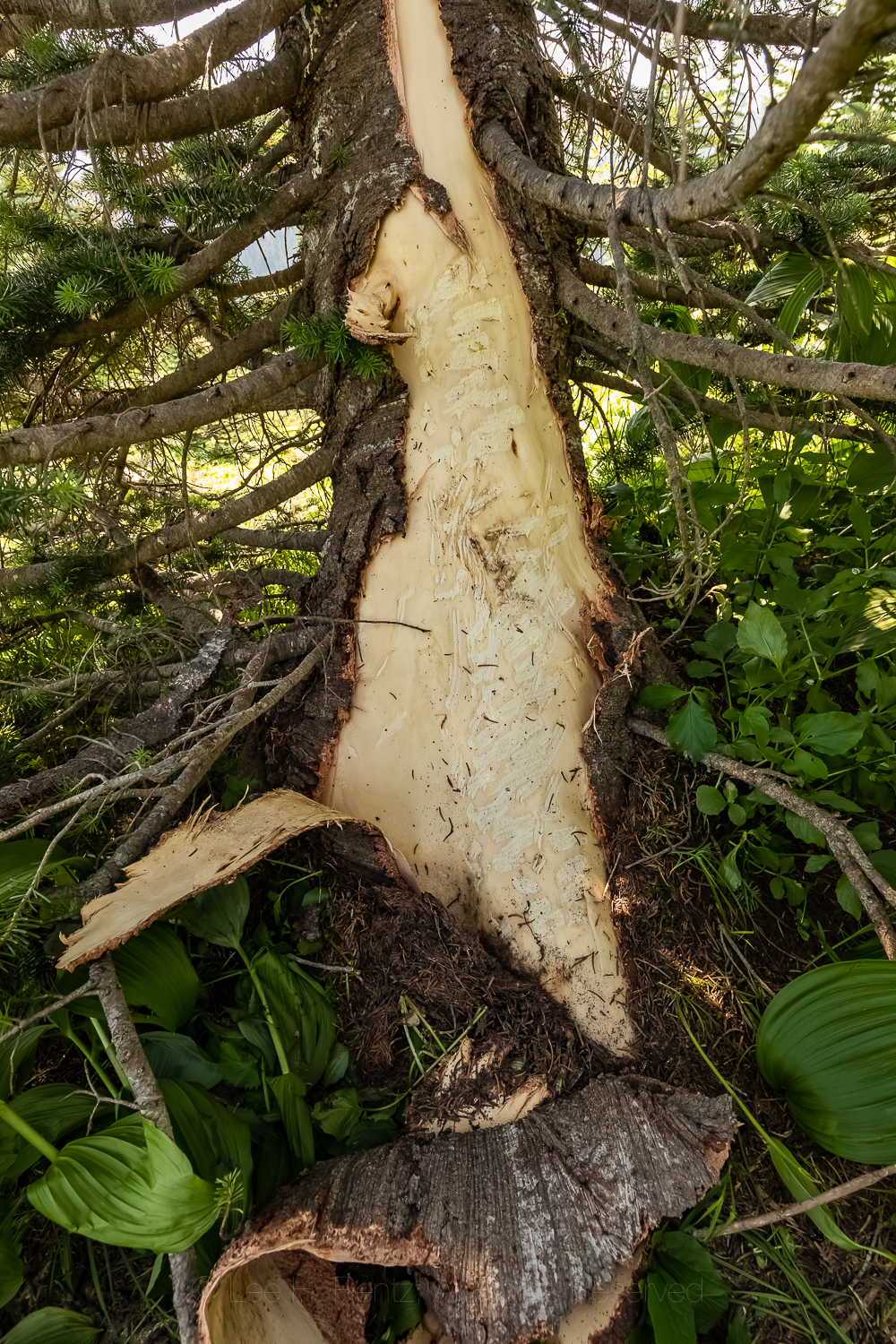
Evidence of an American Black Bear feeding on the cambium of a Subalpine Fir using claws and teeth, in Mount Rainier National Park, Washington State
SURPRISING GRIZZLIES ON THE TRAIL
2010 Mount Assiniboine Provincial Park, British Columbia
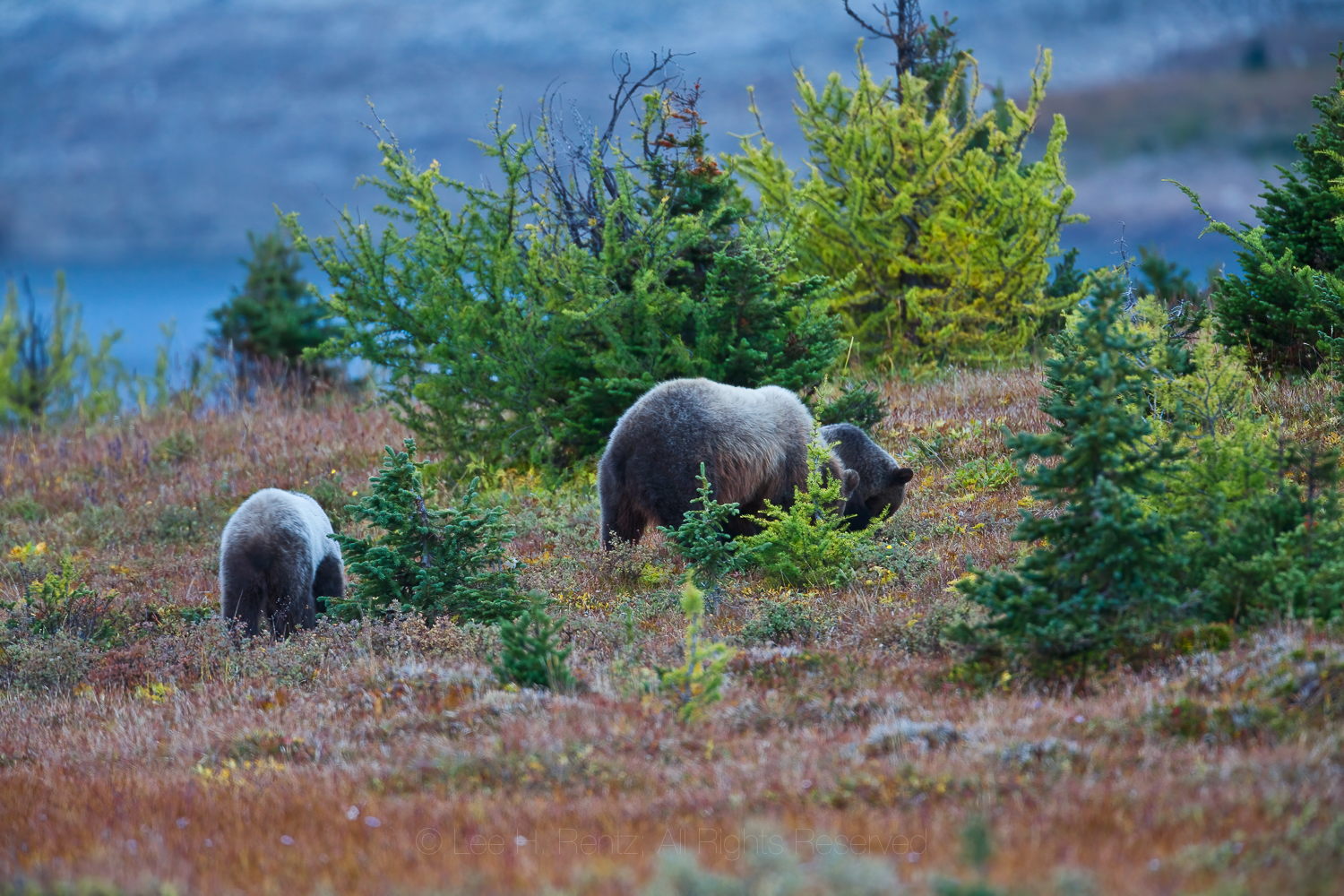
We were high in the Canadian Rockies, staying in log huts with hobbit-height doors during a snowy September. This park is known for its Grizzly Bears, and we had to be careful about walking to the outhouse from the cabin. One morning we awoke to Grizzly tracks near the cabin, heading up a nearby trail we were going to walk later in the day. When we did the hike in a group, we came upon big rocks that the bear had turned over and dug around using the enormous strength in its front legs and claws (these huge muscles terminate in the hump on the back that is characteristic of this species). It had been searching for hibernating ground squirrels or marmots and could quickly dig them out of their winter chambers.
One morning our group rose well before the crack of dawn to walk a trail past Lake Magog and the Mount Assiniboine Lodge and into the trail system beyond. We had headlamps on because it was a dark, cloudy morning. The man ahead of me suddenly stopped and said “There is a big mammal in the trail just ahead.” We waited, and a Grizzly cub, hefty after a summer of ground squirrels and berries, crossed the trail. Then there was another, soon followed by mama. We had our bear spray unholstered and at the ready, and Karen began whistling three loud blasts with her whistle to alert another part of our group that had been late in getting started.
Fortunately nothing bad happened, even though we were in extremely close proximity to the mother and cubs. They left the trail area and moved off about two hundred yards, where the mama began furiously digging for ground squirrels, with the two cubs imitating her. She even stood up on her hind legs repeatedly to sniff the air; we think there was probably a big male–dangerous to her cubs–in the area, based upon a guy we met who was camping with his dog in the nearby campground. His bear encounters were scary enough that he rented a cabin for the next night.
Nothing like Grizzly encounters to set the heart racing!
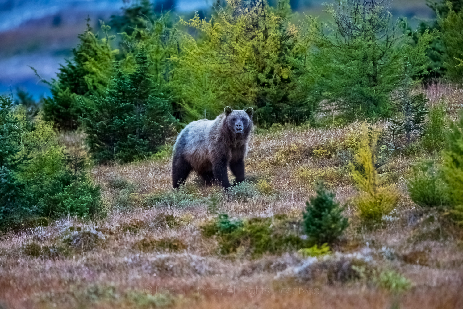
Grizzly Bear mother standing on hind legs after scenting or hearing a possible threat to her cubs at Magog Lake, Mount Assiniboine Provincial Park, British Columbia, CanadaKaren Rentz showing the depth of a fresh hole dug by a Grizzly Bear into the burrow of a Columbia Ground Squirrel, on the border of Mount Assiniboine Provincial Park and Banff National Park, CanadaGrizzly Bear staring with menace at the photographer near Magog Lake, Mount Assiniboine Provincial ParkGrizzly Bear sow and cubs digging for Columbian Ground Squirrels near Magog Lake in Mount Assiniboine Provincial ParkAmerican Black Bear feeding on Gray’s Lovagein Mount Rainier National Park in Washington StateAmerican Black Bear feeding on Gray’s Lovage in Mount Rainier National Park in Washington State
You can see more of the work of photographer Lee Rentz at his website: leerentz.com
The story of our 1984 journey to Gates of the Arctic National Park in the Brooks Range of far north Alaska in words and in photographs. Below the story there are many more photographs that you can click on to enlarge and also see photo captions.
“You guys might want to get out of the tent … there’s a Grizzly out here.” Denis Davis startled us out of our perpetual twilight dreams with that simple statement, and we’ve rarely gotten dressed so fast. The Griz was several hundred yards away on the Arctic tundra and was steadily traveling up the treeless valley. If it smelled us–which it probably did given that we had been backpacking for a week–it didn’t stop to check us out or even look our way. For that we were grateful, given that we had no protection in the era before real bear spray.
This two-week backpacking trip in Alaska’s Brooks Range originated in Denis’ Christmas card for 1983, in which he suggested several possible adventure trips for the coming year to a number of his friends. We were the only ones who responded, and we liked the idea of backpacking in Gates of the Arctic National Park, which was at that time a newly minted national park.
Karen Rentz backpacking in 1984 in Gates of the Arctic National Park, Brooks Range, Alaska, USA
We began planning for the trip in conjunction with Denis and his wife at the time, Elaine. We needed to carefully consider every aspect of our equipment for weight and usefulness. I needed camera gear, including a 500mm lens for wildlife, a macro lens for wildflowers, and a wide-angle lens for landscapes, plus 25 rolls of Kodachrome film. Tents at the time were limited, and we needed a tent strong enough to withstand possible snow, so we brought the legendary North Face VE-25, a favorite of Mount Everest expeditions, but which weighed 12 pounds! Karen brought a hiking staff that was actually a beaver-chewed stick from the Adirondacks; she had to check it on the cross-country flight because the gate attendant said it looked like a weapon. Our clothing was in the pre-fleece era and included items Karen sewed from Frostline kits. We had jeans, army surplus wool pants, wool shirts and sweaters, long underwear, rain-resistant pants, and Frostline parkas. We also each had an insulated Frostline vest; these would also serve as pillows. Plus stocking caps and Frostline mittens and heavy wool socks for hiking. Water-resistant hiking boots were essential to combat the wet tundra and snow.
Lee Rentz backpacking in 1984 in Gates of the Arctic National Park, Brooks Range, Alaska, USA
Considering food, we had to keep it light. Karen used our dehydrator to dry all sorts of precooked meals, not all successfully. Dried shredded cheddar cheese was crunchy and tasty, but melted away needed fats. For lunches we ate Pemmican Bars, which were an early protein bar from the 1980s. For breakfast and dinner we cooked on a Svea stove that ran on white gas. Our simple meals included a commercial beef stroganoff, rice and beans and dried cheese and chocolate. Breakfast always included hot drinks: our standing joke on this mosquitoey trip was that when a mosquito would land in the hot chocolate, we would fish it out, but any leftover mosquito legs would just go down the hatch. We lost weight on this trip because our calorie intake couldn’t possibly keep up with our exertions.
At the start of the trip, Lee’s backpack weighed 78 lbs, with Karen’s about 59. Karen had a full bright orange daypack lashed on top of her backpack; she sewed it from a Frostline kit.
After all our preparations, the time for travel came in late July, 1984. We flew from Syracuse, New York to Anchorage, Alaska. There we boarded a flight to Fairbanks, and then a smaller plane to Bettles, a tiny Alaskan bush town on the Koyukuk River. This is where we did our final planning and packing for the trip, with our gear splayed across the runway’s edge. We talked to some guys who were heading into another part of the Brooks Range who had long rifles with them for protection and hunting; we felt quite naked by comparison. But at the time, it was illegal for hikers to carry a gun in a national park, so that wasn’t even a possibility for us.
With our packs finally stuffed, we walked to the office of the bush plane to give them our final itinerary. We were to be dropped off by float plane at a small lake in the western part of Gates of the Arctic National Park, then we would hike for about two weeks and 50 miles through Arctic tundra, following rivers. Our biggest challenge would be a climb over unnamed mountains, hoping we could get to the crest, then down the steep cliffs on the north side. This was all uncertain, because it was possible no human being had ever traveled this route over the mountains and the available topographic map was not detailed enough to confirm cliff locations. This was real, raw wilderness in the extreme. If all went well, we would follow a drainage from the mountains, hiking north until we reached Kurupa Lake, where we would be picked up by float plane.
Dramatic arctic landscape between the Arctic plain and the high summits of the Brooks Range, Gates of the Arctic National Park, Alaska, USA
We finally shouldered our heavy packs and walked to the Koyukuk River, where our float plane magic carpet awaited. This was a Canadian-made bush plane, a De Havilland Beaver, that was and is the workhorse of the far north. We took off from the river–our first experience on a float plane–and followed the river west for a ways, with us watching for Moose among the Black Spruce trees along the river. Eventually the pilot left the river and turned the plane north, taking us over turquoise tarns and rugged, sharp peaks where the trees eventually dwindled to none, leaving us over a treeless tundra. We came to a broad opening in the mountains where several lakes shimmered, and one of those was our destination. The pilot descended and made a smooth landing on the lake, then taxied over to the shore. We didn’t even get our feet wet while unloading our gear. After confirming our final meeting point for a rendezvous two weeks later, the pilot taxied into the center of the lake, then took off with a roar, leaving us feeling lonely on the vast tundra. The pilot had been instructed to pick us up at Kurupa Lake, but if we weren’t there, then he would look for us at our drop-off lake in case we couldn’t make it over the mountains.
Two things happened within minutes: we found a distinct fresh Gray Wolf track in the wet soil between tussocks, and mosquitoes descended upon us in Biblical multitudes. We were in the Alaska Wilderness!
After a few minutes of gazing out over the lake, we pulled out our mosquito head nets, shouldered our lead-filled packs, and set out on a two-week journey through one of the wildest places in North America. We consulted our topographic maps, then headed over a ridge that looked down over a long valley stretching toward a line of mountains in the distance. Our route would take us down the valley along an unnamed river past unnamed mountains.
Our trip took place at the warmest time of year in the Brooks Range, with temperatures hovering above 70°F. At our feet, arctic wildflowers bloomed in profusion–most of them hugging the ground to avoid the drying winds–while along the river Arctic Fireweed was vivid. In this warm weather, the clouds of mosquitoes were legendary. To cope we wore head nets, plus applications of DEET-containing Jungle Juice. Karen had sewn the placket gaps above our sleeve cuffs shut to keep the bugs out. But we discovered that they could still bite through our jeans, so we ended up with a lot of itchy welts. During the first two days of hiking along this long valley, we saw no large charismatic wildlife, so we focused upon cool birds we had never before seen, such as a Wandering Tattler on its nest site, an American Golden-Plover, and a Gray-Crowned Rosy Finch.
We set up our first campsite on the lower flanks of a mountain high above the valley. This was northern Alaska during the height of summer, so the sun barely set, making the inside of our yellow tent look like perpetual dim daylight all through the long night. We thought it might be hard to sleep in these conditions, but we were so worn out from hiking with heavy packs that sleep was not a problem. As we gazed up the valley the next morning we could see where we would camp the next night; an expansive view.
Grizzly Bears were always on our minds, but not enough to keep us from sleeping. Without bear spray and without guns, our defense lay in our numbers–with four of us, that should work as a deterrent against daytime attacks. At night, we needed to protect our food supply from bears, but there was no place on the open tundra to hang our food. Each night we took our packs and placed them together about 100 yards downwind from our tents. Atop the packs we placed our cooking pots with stones in them, so a raid on the packs would alert us with noise. We also had little mesh bags made by Karen containing mothballs that we hoped would cover up the scent of food, or at least serve as a repellent. While hiking, the mothballs were triple bagged to contain the strong fumes.
The next day we hiked further along the river, coming upon a spot where there was enough shade from the mountains that river ice several feet thick had not yet melted; it resembled glacial ice, with its aqua-blue color. Later, we were setting up camp when we heard the blowing and galloping of a mammal coming our way. It was our first Caribou, and it appeared to be running in terror. But nothing was chasing it, and it was possible that there was a parasitic larva called a nosebot driving it crazy. Or maybe it was the ever-present mosquitoes.
The third day out, we left our broad, open valley and began ascending a steeper route into the mountains. This was the drainage we hoped to take over a high pass at the northern crest of the range. As the day wore on, the cloud cover increased and there was a noticeable chill in the air. We set up our tents high in a cirque, with sharp peaks rising around us, then finished our camp chores and wriggled into our sleeping bags. A drizzle began, followed by rain, then silence.
When we awoke the next morning, there was about four inches of fresh snow on the tents. It was cold, and we decided it would be too treacherous to make our climb over the pass in these conditions. So we took a snow day, mostly napping and reading inside our tents, waiting for the weather to pass.
We hiked to a snowy, high, unnamed pass in Gates of the Arctic National Park, in the northern part of the Brooks Range, Alaska, USA [No model release; available for editorial licensing only]
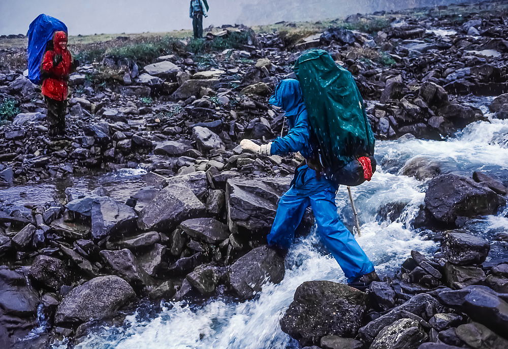
The following morning the weather had again changed, with sunny blue skies appearing between clouds still hanging in. We decided this was our day to face the biggest challenge of the trip, so we loaded up and headed straight up the snowy steep and rocky slope toward the pass. When we reached the pass, the view straight north to the Arctic Plain greeted us. The wind was blowing hard over the pass, so we took shelter against a rock buttress and ate lunch. Then Denis and Lee split up to try to find a safe route down from the pass. Denis went to the east and Lee ascended to the west, each looking carefully at our chances. When we got back together, Denis said his side of the pass was not feasible, but Lee decided we had a good chance of making it if we carefully went in his direction. It involved climbing higher, then going sidehill in snow while hugging a cliff above a steep, snow-covered dropoff. If we went far enough, we would reach a scree slope leading all the way down to the valley at a steep angle.
Lee turned to Karen, who gets nervous with exposed heights, and said “You’re going to have to be brave.” She was, and we carefully inched along the cliff face without mishap, then began our steep descent. The scree slope was snow covered, but we forcefully stuck our legs through the snow to the soft rocky debris (almost like a fine gravel dune) and felt almost entirely safe. When we made it to the bottom, it was with a sense of triumph and relief that the most difficult part of the journey was behind us. We celebrated by making a no bake boxed cheesecake chilled in the snow, and all was right with the world.
The bad weather closed in again the next morning, and we hiked down the length of a lake with wet snowflakes steadily falling. Very briefly the mosquitoes were too chilled to move. The mountains were gleaming with their coat of fresh snow. We climbed out of the valley into some foothills. Then, while eating lunch we saw movement in the distance. Binoculars revealed one of the most amazing sights of our lives: thousands of Caribou traveling across the rocky terrain! We changed our route to intercept the herd and over the following days we watched and photographed them extensively, burning the sight into our memories as well as on film.
We camped that night on a ridge in the path of the Caribou, and all night we could hear the clicking of tendons in their ankles as they walked past our tents. It is a fascinating phenomenon, and apparently it serves to keep herds together as they travel–even in the clouds and fog of the mountains they can hear each other enough to stay together. The Caribou traveled well-worn paths along mountain slopes and through wildflower meadows. There were bull Caribou with huge antlers, as well as females with smaller antlers and young of the year racing around. These were part of the Western Arctic Caribou Herd, which migrates twice yearly between the calving grounds on the Arctic Plain and the wintering grounds south of the Brooks Range. When we saw them, they were gathered together in a huge group, but not yet beginning their fall migration south. Our days among the Caribou were wonderful, as we saw them crossing streams and silhouetted against snowy mountains.
Caribou, Rangifer tarandus, migrating through the mountains of Gates of the Arctic National Park, Brooks Range, Alaska, USA
On another morning about this time in the trip we saw our first Grizzly Bear; fortunately it didn’t pay us any attention. It was astounding to see how large it was and how prominent was the hump on its back. One advantage of hiking in the tundra is you can see bears from a long way away. We still remember Denis and Elaine talking about being first on the scene of a near-tragedy in Glacier National Park. A family of four had been hiking together when they surprised a Grizzly in the forest. It attacked, and had one child’s head in its gaping mouth when the father jumped on its back. The bear broke the man’s arms but then called off the attack. But enough about scary bear stories.
Our packs were now a bit lighter from the food we had consumed, and our still-young bodies gained strength as the days wore on. One day Denis proposed we go off on our own and he and Elaine do the same. That sounded good, and we ventured into the Kurupa Hills. Our highlight was seeing a young Dall Sheep lying on the tundra, and later seeing some adults crossing a talus slope. At our campsite we enjoyed watching an Alaska Marmot, though not-so-much an Arctic Ground Squirrel who chewed through one of our plastic water containers. During the second half of the trip we saw Peregrine Falcons, which were truly rare in the lower 48 during the 1980s because of the effects of DDT, as well as a Long-tailed Duck on a tundra pond, and Long-tailed and Parasitic Jaegers, which flew at us aggressively when we got too close to their nesting grounds.
Hiking further, we approached our destination, Kurupa Lake. Denis didn’t tell us at the time, but later said an early oil prospector’s report described the “herds of Grizzly Bears” at Kurupa Lake. Fortunately, we encountered no herds, but we did see a second Grizzly Bear on the other side of the lake, where it paused to furiously dig up an Arctic Ground Squirrel’s burrow. It is astounding how fast those massive muscles and claws allow a Grizzly to dig. We assumed it got the squirrel.
We stayed two nights at our last campsite, giving the bush plane plenty of time to retrieve us. While we waited, Karen and Denis both fished, each catching a Lake Trout and observing Arctic Char. Denis released his fish, but Karen was determined to eat ours. So we cleaned the fish and boiled it, tossing the carcass into the lake to reduce the scent. It was good, but the scent from the cooking would have clung to our wool clothing, undoubtedly acting as a lure for a bear. Fortunately we didn’t attract any bears to camp.
There was always a chance the plane would not appear on our pickup date; if fog or other bad weather delayed previous days’ retrievals, people would be picked up in order and they would get to us as soon as possible. We were getting low on white gas and food and speculated that if we were delayed by days we would be eating raw fish.
We were entranced by the whole experience, and Lee could have turned around and stayed in the wilderness for another two weeks if we had the time. Alas, work called and we needed to return. On our last day we needed to pack early and have our gear ready to go. In the afternoon we heard the whine of a plane approaching, and it turned and descended to our lake. The pilot had instructed us to leave a tent up so he could spot us along this large lake. As soon as we knew the pilot had spotted us, the tent was quickly collapsed and we hoisted our packs to trudge down to the shore, then loaded our gear onto the float plane. When we took off, it signaled the end to one of the signature experiences of our lives.
The photographs below show a map of our route, final packing on the runway in Bettles, our flight north through the mountains, and our first moments on the arctic tundra. Click on any of the pictures for a larger view and more information.
As we hiked across the tundra with our heavy packs, the Arctic revealed itself in beautiful wildflowers, distant views, Caribou antlers, fast streams, and campsites with glorious views.
We identified and photographed wildflowers and lichens and ferns that we had never before seen. The tundra plants are short, hugging the ground to stay out of the wind and take advantage of the warmth near the ground; most of the wildflowers are pollinated by flies, since bees are scarce in the Arctic.
When we reached the end of a long valley and several days of warm temperatures, our route next led us into the mountains. After setting up camp, rain turned to snow. After a rest day, we climbed steeply up into the mountains, not knowing if we could cross the range here. It turned out that we could, although there were challenges of negotiating ice and snow and a steep scree slope.
After the steep mountain crossing we hiked down a long valley in rain and snow, passing alpine lakes and crossing a stream. Here our wildlife sightings began in earnest, with Grizzly Bears, Caribou, Dall Sheep, and birds we had never seen before. Seeing thousands of Caribou was a highlight of our lives.
After all our time in the wildest wilderness we had ever experienced, it was time for a float plane to pick us up at Kurupa Lake on the north side of Gates of the Arctic National Park. We arrived two days early and spent the extra time fishing and hiking. Alas, we heard the plane overhead and quickly packed up, ending one of the premier adventures of our lives.
Wilderness and adventure in far off places would lure us to distant locations and backpacking trips during the ensuing decades, but nothing would be quite the challenge as this trip to the Brooks Range. Looking back now, nearly four decades later, we both think of it as a highlight of our lives.
The pleasant white noise of water running over rocks in the North Fork Skokomish River blends with the occasional warning clicks of a concerned Pacific Wren and the wind rushing through the needles and leaves of conifers and maples. Low angle sunlight occasionally shines through the brilliant orange leaves of Bigleaf Maples along the river’s edge. A family of American Dippers walks underwater through the rapids, searching for insect larvae. A cousin of the robin, the Varied Thrush, has migrated in for the winter and individuals are foraging through the mossy forest.
Each time I come to Staircase, named for an actual wooden staircase that a military expedition built to climb over rugged nearby cliffs, I am enchanted by the exotic lifeforms that populate this rainforest. There are the Icicle Mosses that drape the limbs of maples and dead conifers so thickly that I wonder how the branches can support the weight of this wet mass of moss.
There are Dog Vomit Slime Molds that we encounter in the woods. These are neither plant nor animal and normally live their lives as single cells, but when something triggers them, these cells come together to act as a larger organism that actually oozes through the forest in a search for food.
There is the Methuselah’s Beard, the longest lichen in the world, hanging like Spanish Moss from the limbs of riverside maples and firs. It is the Methuselah’s Beard that attracts me to frequently return to Staircase. There is one special Bigleaf Maple that the lichen has enjoyed living on for years, to the point that much of the tree looks decorated in fake spider webs for Halloween. I thought I was the only photographer attracted to this tree, but it turns out there are many others; on one recent trip two photographers came by while I was photographing and said that they make pilgrimages to photograph this tree every autumn. This lichen species is extremely sensitive to air pollution and is used by scientists as an indicator of poor quality air; it has been declining across much of its range around the world for this very reason. But at this location on the Olympic Peninsula, bathed in moisture coming off the Pacific Ocean, the air is clean and wonderful. The lichen thinks so as well, and looks to be content living here.
Click on each of the photographs below to see them larger. Much more of my work is at leerentz.com. Reach out to me at lee@leerentz.com if you have any questions.
The Appalachian Trail winds through the lush forest of the Great Smoky Mountains
Memories of our formative years can remain incredibly vivid into old age. This account tells the story about my hiking trip along a section of the Appalachian Trail with Dowell Jennings Howard III after our spring semester concluded in 1970. Back in the University of Michigan dorm that winter, I had talked with my friend for a long time about how America’s young people needed to incorporate more adventure into their lives, so I pumped him up for the possibility of a May hiking trip along the Appalachian Trail where it passed through Great Smoky Mountains National Park. We agreed to do it, and set the plan in motion.
I was a forestry student, while Dowell was studying mechanical engineering. He came from a family in the Cincinnati area that had deep roots in America, and his father worked for Procter and Gamble. His personality was a contrast to my shy and introspective traits; he was friendly and outgoing and was the kind of person who would run for office in student government. These traits were good for making connections while traveling.
We planned the trip, divvying up food purchases and making sure we had appropriate gear for a spring trip in the mountains. We purchased dried eggs and dried sausage that had to be rehydrated before cooking. There were dried noodles and beef and chicken, some packaged in cans instead of plastic. We packed socks and long underwear and warm hats and hiking boots and rain ponchos and matches and all the rest of the gear we thought we would need. I’m sure we hiked in jeans, which few would dare to do today because cotton is slow to dry and doesn’t keep a person warm when wet, but we didn’t know better.
After the semester ended, I flew from Detroit to Cincinnati on an old propellor-driven commercial plane, met my friend for a ride to his parents’ house, then we headed out on a Greyhound bus trip to Knoxville, Tennessee. The overnight bus ride was an experience in itself. The bus curved around constant mountains in the dark, stopping for a break in the middle of the night at a diner in Corbin, Kentucky. I still remember the clank of china and the harsh overhead lights and green walls that looked like they could have been the setting for an Edward Hopper painting.
After a transfer at the Greyhound Bus Station in Knoxville, we next rode a bus to Gatlinburg, Tennessee, where we stayed at a motel overnight and were interviewed on the street by a local television station about what we were doing in Gatlinburg; Dowell was a natural for television interviews with his politician’s aura, while I stayed in the background. The next morning we hitchhiked to a Great Smoky Mountains National Park campground. There we set up a tube tent that I had made, since I didn’t have money to buy a real backpacking tent. My tube tent was made from a sheet of clear plastic sheeting. I took a piece of plastic maybe 18 feet long and 8 feet wide and taped together the ends. When we set it up, we ran a parachute cord through it which was strung between two trees. It gave us shelter from the rain overhead, as well as a floor, but the ends were open to mosquitoes and no-see-ums.
At the campground we set up our tent, had dinner and told stories, then strung up our food to keep it away from bears and raccoons. Alas, we were virgins in the ways of clever bears, and the next morning we awoke to find that a Black Bear had raided our backpacking food before we could even start our hike. The cans of dried meat were opened as if with a can opener by the bear’s teeth and claws and there were tooth puncture marks and bear saliva slime on plastic food pouches. Now we had a dilemma: not enough food for our backpack. A kind man offered us a ride back to Gatlinburg to get a new food supply, but he decided halfway there that a convenience store was good enough. So we shopped there and ended up with a big jar of combined peanut butter and jelly, some canned meats, probably Vienna sausages, and crackers. The meals were going to be a bit more haphazard than we had planned, but we were young and adaptable.
After that we repacked our backpacks and started up a steep and rocky trail to where it intersected with the Appalachian Trail. The pack was heavy and the hiking was really hard after a year of studying at college with not much physical activity. It was a relief when we finally reached our first trail shelter, which was a three-sided structure made of ancient logs that smelled of years of accumulated smoke from wet campfires. One feature of the shelter that we both liked was that the front was closed off by ground-to-ceiling chain-link fence–designed to keep out marauding bears. We cooked over a smoky fire from downed wood gathered in the surrounding forest; most hikers at that time cooked this way because few had lightweight backpacking stoves. The Appalachian trail shelter had two platforms inside that spanned the width of the shelter, one upper and one lower, where quite a few people could sleep side-by-sde. We settled into our flannel-lined sleeping bags early and slept pretty well, considering all the mice scurrying around the shelter in the night.
After another smoky meal the next morning, we started hiking the Appalachian Trail, which would take us some 70 miles through the park, doing about ten miles a day. Painted Trilliums and other wildflowers bloomed along the trail on our May hike, and we had frequent glimpses through the trees of hazy mountains in all directions. We had learned that the blue haze was not smoke or pollution, but instead consisted of vapors given off by the incredible concentration of trees: the Indians called it the “Land of Blue Smoke.”
Memories of the vast forest
One guy we met at a trail shelter said that he had organized the first national Earth Day that spring. I told him that I had worked with the Environmental Teach-In at the University of Michigan earlier that same spring, so we had something in common. He was out for a dose of nature after finishing all that planning and coordination.
Along the trail I found out that my borrowed backpack was too lightweight for the heavy load I carried, and the aluminum support structure bent and broke when I repeatedly set the pack down on the ground when we took a break. To salvage it for the long trail ahead, I borrowed two dead spruce branches from the forest and lashed the broken aluminum to them. A bit crude-looking, but it worked. When in the wilderness, invention and adaptability are crucial.
On we hiked through a forest of deciduous trees just leafing out. We came to Charlies Bunion, a bare block of rock with steep drop-offs that terrified me, a flatlander. That night we stayed at the Mount LeConte Shelter, with the intent of having dinner at the legendary and rustic LeConte Lodge just a short distance up the trail. We dropped our packs in the shelter. Dowell wondered if we should hang the packs but I was tired and said no; we were just going a short distance to make dinner reservations. We walked up to the lodge and got our reservations, then hiked back to the shelter–just in time to see a mama bear and her two cubs biting into our packs to try to get at the food inside. We chased them away by throwing rocks, but Dowell’s pack was pretty bitten up. I apologized to him for not hanging our packs, but it does give me something to write about 50 years later!
The high ridges of the Great Smoky Mountains seem to go on forever
We had our meal at LeConte Lodge, which was hearty and filling but nothing fancy, then watched a sunset from the mountain, where the legendary blue ridges of the mountains go on and on. It was the best view along the trail, and the light was magical.
The next day we crossed the only road through the mountains at Newfound Gap, where a woman made up like Dolly Parton, and her husband, offered us beer and took our pictures. By that time on the trail we were a pair of grubby young mountain men on an adventure that seemed exotic to the tourists.
On to another trail shelter, this one occupied by two grad student bear researchers from the University of Tennessee and a troop of Girl Scouts from Knoxville. The scout leader, Mary, was a wonderful young woman who was taking the girls on an adventure of their lives. None of them knew how ugly it would get.
A few minutes after we arrived, half-a-dozen men in their 20s walked up to the shelter. They had been drinking heavily on the trail, with at least one of them carrying a gallon jug of Gallo red wine with his finger curled through the loop on the jug’s neck. Almost immediately, this guy and others started making sexual comments to the young girls, which was among the most inappropriate scenes I’ve ever experienced. It looked like these guys were going to spend the night at the shelter, but the shelter was already full. Were they going to physically kick us out?
These guys, one of them explained to us, had just returned from Vietnam where they had been involved in combat in the jungle. They were tough, and big, and dangerous, and they didn’t like college students, who they would have thought of as protestors with deferments (which we were!). Combined with the alcohol, the discussion among them got ugly. Fortunately, one cooler head among them convinced them to hike on to the next trail shelter, so they left. Crisis averted.
We made friends with Mary, and agreed to look her up when we passed through Knoxville on the return (which we did, and stopped at her apartment for a nice candlelight spaghetti dinner on her kitchen table–which was one of those wooden cable spools popular among college students at the time). We were impressed by her leadership of the Girl Scout group and how she believed in mentoring girls in outdoor experiences.
On we hiked along ridges with stunning views of the great Appalachian forest, lush with growth. We stayed at the Silers Bald shelter, high along the trail, which gave us a view of dark and ominous clouds. At this shelter we talked for a long time with an old and grizzled mountain man from nearby Bryson City who had hiked up with three young men. Actually we had seen the young men earlier, and one was pulling a two-wheel golf bag cart up the trail–filled with bottles of beer! That explained all the hootin’ and hollerin’ from their campsite during the night. They had a big and blazing campfire that I’m sure was set in the traditional Appalachian manner: dousing the wet wood with gasoline, standing back, and tossing a match at it to watch it explode!
The next morning, a wet fog had settled over Silers Bald and we couldn’t see a thing through the thick sky soup. Another hiker came up to us while we were on the rock; he was thin and maybe 40 years old. He asked us how much we hiked in a day and we responded that we hiked about eight to ten miles a day. He wasn’t impressed. He said that he averaged over thirty miles a day and that his best day was 43 miles. I’ve never had the ability or the body type to do that kind of hiking, and it wouldn’t work with all the times I stop to take photographs, so in retrospect I’m not impressed, though at the time I thought he was superhuman.
By that time on the trail my feet were sore. Even though we washed our socks and dried them by the nightly fires, the trail had done its job on my tender feet. I had a blood-filled blister the size of a half-dollar on one heel, so I limped my way along the trail to the trailhead. We hitched a ride to a campground, where Dowell made friends with an older woman (she was probably 25) who was a teacher, and she took us the next day to go for a hike to a waterfall. That was fun, and this was a more trusting time in America, when people weren’t as afraid of each other. She drove us to the Gatlinburg bus station the next day, where we caught the bus to Knoxville. I distinctly remember the fat bus driver telling us and a couple of other hikers that he didn’t think backpacking was very sporting, so he wasn’t very impressed by us. Oh well.
In Knoxville we had just enough time to walk to Mary’s apartment for a meal, then walk back to the bus station where we boarded the overnight bus to Cincinnati. The atmosphere on the bus was electric, because many of the rural Kentucky and Tennessee passengers had just come off an experience attending a Billy Graham crusade that took place on May 28, 1970, in Knoxville. They felt inspired and chatty, talking about their churches and children and chickens.
We arrived in Cincinnati the next morning, where Dowell’s mother fussed over and treated my blood-filled blister, then we drove out to the family cabin in rural Ohio, which was a rustic place done in the Appalachian style with a long covered front and back porch. Dowell took me fossil-hunting in the nearby creek. In his high school years, he had been an avid fossil-hunter and actually had at least one scientific paper to his credit. The next day I flew home and began preparing for a summer semester in Michigan’s Upper Peninsula.
Epilogue: I just finished writing this a bit over 50 years after the experience, surprised at how much of it still felt fresh in my mind. Early experiences can be like that, imprinting themselves on a still-impressionable young person. I lost track of Dowell a year or two later; I only know that he graduated with a degree in Mechanical Engineering. I went on to get my degree in Natural Resources, and later worked in that field and in photography for the rest of my adult life.
There are places where experiences are so profound that they draw you back time after time. Olympic National Park’s Shi Shi Beach and Point of Arches is such a place for me. The words in this story are from our 1991 field notes of our first visits to this transcendent place, illustrated with new and old photographs presented in a nostalgic style.
Hikers and Point of Arches rocks at sunset, viewed from Shi Shi Beach along the Pacific Ocean in Olympic National Park
January 18-21, 1991
With a weather report of sunny weather for Western Washington through the long Martin Luther King holiday weekend, we made a quick decision on Thursday to leave Friday for a three-day backpacking trip along the coast at Shi Shi Beach and Point of Arches. Little did we know it would be the most spectacular weekend trip of our lives.
We drove to Kalaloch on the Washington coast Friday night and camped in the Olympic National Park campground along the shore. Clear skies, with intense starlight, were followed by a heavy frost the next morning.
Arising early, we drove to Neah Bay and the Makah Indian Reservation. The road between Clallam Bay and Neah Bay hugs the twists and turns of the coast. Along this stretch of the Strait of Juan de Fuca, we observed four immature Bald Eagles perched in the trees between the road and the water. Additionally, a male and female Harlequin Duck perched together on a small emergent rock. We also observed loons and scoters offshore, as well as Double-Crested Cormorants.
Neah Bay, the heart of the Makah Reservation, is like a small town on the Newfoundland coast, with scattered houses strung along the shore, a small fishing fleet, and no pretense of being a tourist town. These Indians had a centuries-old tradition of whaling from open canoes.
Karen Rentz hiking on Shi Shi Beach along the Pacific Ocean in Olympic National Park
We followed a convoluted route to the trailhead, through town and along some potholed roads. Along Waatch Creek, we came upon wintering Trumpeter Swans. The brilliant white swans made a wonderful sight as they swam across the peaceful river surface, which reflected the pale blue of the winter sky. Their resonant trumpeting provided a sound track for the experience.
The two-mile hike to Shi Shi Beach was a muddy challenge [much improved in recent years], but the sounds of the roaring surf urged us on.
At our first ocean overlook, we watched waves crashing through the offshore sea stacks. As we started eating lunch, we noticed two mature Bald Eagles majestically perched together atop a high sea stack. Looking through binoculars at the ocean’s expanse, while enjoying a trail lunch of summer sausage and Wheat Thins, I spotted the spouts of three Gray Whales offshore; these were unmistakable columns of mist going straight up from the ocean.
Driftwood logs deposited during fierce winter storms on Shi Shi Beach along the Pacific Ocean
As we shared a chocolate bar, Karen noticed that a “log” rocking on the waves was, in reality, a Sea Otter. Floating on its back, it was holding a Sea Urchin up to its mouth with its front paws. The back paws were stuck up in the air. The otter floated like a cork over crests and troughs of the waves–except when a giant wave toppled toward it–then it would plunge into the wave and emerge on the other side.
Hoisting our packs, we continued down the trail and in a few minutes descended to the beach. We were surprised to see a young man running along the beach and through the surf in shorts, sans top, and barefoot; his girlfriend sat in the sand and watched and shivered at the thought of it.
We decided to set up camp near the Olympic National Park boundary, at a place where a Raccoon-proof cable was strung between two trees [currently ALL overnight visitors are required to bring bear-proof canisters].
Then we hiked north along the beach we had examined from above. From the shells on the shore, it was evident that there were extensive California Mussel beds offshore. We also saw a few Razor Clam and Butter Clam shells; opened and empty, but (like the mussels) the hinges still held the two shell halves together and flexible. A Common Loon dove just offshore, as did a Surf Scoter; we saw the Sea Otter’s head poke up a few times as well. An occasional Bald Eagle sailed overhead.
Sandy shore ripples of Shi Shi Beach at low tide
Karen went around the next small point to the north and saw parts of an old shipwreck. Two large rusted hulks were on the beach, one large section out near a sea stack with a “gun turret” point projecting, and other pieces of metal scattered through the bay. Karen continued north to the beginnings of a cave being formed, and then further to a deeper cave which was still inaccessible because the tide was not low enough. The sun was setting though, so it was time to head back to camp.
When we returned to camp, we discovered that a Raccoon had unzipped Karen’s pack and investigated all its contents. We knew immediately that the culprit had been a Raccoon (and not a person), since Karen’s driver’s license and credit cards lay prominently on top of the pile spread across the ground–the Raccoon apparently didn’t have much use for Master Card. It had chewed up part of a roll of toilet paper, but otherwise no damage was done, since the food was strung safely up on the wire.
We crawled into our sleeping bags at 8:30 pm, and fell asleep shortly after. At midnight, we awoke to the sound of packs being rifled. Lee checked with a flashlight and caught the eye shine of two Raccoons. He crawled and chased them off. Undaunted, they returned a few minutes later, so Lee crawled out again and escalated the conflict by tossing sticks and stones at the creatures. This worked for a time, but they were back again a couple of hours later. This time Lee was running around barefoot in his underwear yelling and throwing stones at the guerrillas.
Lee awoke to the screeching and snarling sounds of a Raccoon squabble a little while later, but soon the action quieted down and the rest of the night was peaceful.
Wet sand on Shi Shi Beach after a wave subsided
Waking up groggy and grumpy the next morning, Lee had a hard time getting started–as might be expected. After hot instant coffee and cold granola with powdered milk, we started down the beach in the cold gray of dawn. Again, there was frost whitening all the drift logs and grasses on the beach. The sand above the high tide line was frozen.
Shortly we came upon a dead seal washed up during the night’s high tide. The 5-foot long seal appeared freshly dead; one eye had been pecked out by crows or gulls.
Rock formations of Point of Arches with a tide pool along Shi Shi Beach at low tide
Far down the beach we spotted a live Harbor Seal wiggling its way from the high tide line toward the sea. Obviously uncomfortable on land, it moved vigorously with ripples of fat rolling like ocean waves down its body. It would rest briefly, then struggle on. It finally reached the water and prayed for a big wave to carry it off–one of which arrived several waves later. We examined the tracks, which showed the lines where flippers made their marks, perhaps 2 feet apart. One flipper consistently dug in deeper than the other–perhaps indicating an injury that would have made movement more difficult.
The beach was relatively free of human detritus, though there were the usual fishing net floats, lengths of bright polypropylene rope, and tattered net fragments. At the highest wave line, there was a sprinkling of tiny bits of brightly colored plastic–which looked like plastic confetti. This was the first time we’ve seen such plastic bits. The larger pieces break into small pieces from the incessant pounding of the Pacific.
Wet sand and rocks on Shi Shi Beach after a wave subsided
Never still (even on perfectly calm days under an intense high pressure zone like these days) the Pacific shore here always has the hearty roar of the surf as kind of a white noise in the background. Lee remembered talking with Dad on the phone, when he mentioned being at Kalaloch during the 1970s, and turning the car so its headlights struck the ocean, and being astounded and (if I may read something into this midwesterner’s memories) a bit intimidated by the churning, pounding, roaring surf that never ends. His memories of the violent Pacific were vivid, having stood watch in a crow’s nest atop a WWII destroyer during a big storm at sea.
As we stood among the sea stacks, on rocks exposed by low tide, we were awed by the pulsing power of the surf as it crashed into the monoliths and surged into the bays. The rocks absorbed the power and broke up the waves, thank goodness. Note that the big waves came in surges of a half dozen or more high peaks, followed by a period of relative calm. Reading Ricketts and Calvin’s Between Pacific Tides, the authors say that being within 20 vertical feet of the ocean is actually risking one’s life; clearly we need to be prepared for these big wave surges.
Man walking in the morning sea spray mist on Shi Shi Beach
As we sat down for lunch, Lee saw a falcon hunched on the beach just above the wave line. It remained for a minute or so, then took off with powerful wing beats and flew past us along the beach. It was a Peregrine Falcon, the Pacific Northwest dark phase of the bird.
We spent the late afternoon on the exposed rocks, watching the scene and photographing the sunset colors playing among the sea stacks.
Sunset behind sea stacks at Point of Arches
We waited until dark to start back toward camp, and enjoyed an enchanting 1-1/2 mile walk along the beach by the bright light of a winter moon. The dance of moonlight on waves, the sound of surf, the call of a distant foghorn, the rhythmic ray of the Tatoosh Island lighthouse, and the Milky Way and stars shining intensely overhead all made for a memorable night walk on the hard-packed sand at low tide.
Another dread night of the living Raccoons lay ahead. This time they attacked even before we got in the tent; but Lee savagely counter attacked with driftwood missiles. After a couple of half hearted sorties around the tent, the Raccoons retreated, granting us peace the rest of the night.
Morning dawned with a light mist over land and sea, and we headed down the beach again.
When we got to Point of Arches, we scrambled out on the exposed rocks. Karen discovered that there were indeed a great many starfish, despite the initial feeling that few were there. A few bright orange individuals stood out from their hiding places because of their brilliant color, but most of the sea stars were camouflaged by their subtle red-purple coloration, which perfectly matched the shade of the red algae covering their hiding place. Scores of them were tucked under ledges in shallow pools.
Ochre Sea Star at Point of Arches
Another sea star was astounding! With 22 legs and an 18″ legspan, the reddish-purple Sunflower Star moved rapidly (for a sea star) over the rocks as it hunted. It had an orange central (or almost central) spot on the top side of the body.
Karen also noted the abundance of Hermit Crabs: when we walked up to a tidepool it would be alive with movement for a moment, but then everything would freeze and the pool would appear lifeless. In reality, nearly all the shells were inhabited. Karen saw two hermit crabs fighting over a rock overhang. Neither were inside shells, but one of them had two small shells on its smaller claws–like boxing gloves–and it really looked funny.
Two Black Oystercatchers perched on a nearby rock, one facing one way, one the other. They often stayed on rocks that the incoming tide surged over, perhaps finding these conditions ideal for feeding.
Black Oystercatchers gathering at Willoughby Creek on Shi Shi Beach
We then wandered south along the beach while the tide was still low, exploring sea caves and arches along the way. A mature Bald Eagle patrolled the beach overhead. On the next point there were vast, flat exposed tidal areas.
The highlight here was seeing two male Harlequin Ducks in exquisite low-angle sunlight. They were perched on a rock in the middle of a tide pool, both facing the same direction. Lee grabbed some quick pictures, but scared them into the ocean, where they were joined by another male and two females. These birds float over the crashing surf with ease, ducking under a cresting wave when need be.
We decided that there are up to three hours on each side of the low tide mark when it is safe to round the Point of Arches. Next time we want to spend more time exploring the next point south, which has many arches; we walked through one.
Lee’s sandy and wet bare feet on Shi Shi Beach
There were Deer and Raccoon tacks on the sand, and people occasionally see Black Bears and Cougars on the beach. There were a few exuberant people sharing the beach these couple of days, and I think everyone felt that it was a special time to explore this most wild and glorious of places.
We found a size 3-1/2 women’s Nike tennis shoe with Gooseneck Barnacles inside. Further down the beach, Karen found the mate to the shoe, also with barnacles inside. There was ship that lost a container of Nike shoes off the coast, and they show up occasionally.
The trail guidebook says the total round trip to Point of Arches and back is 7 miles. There were quite a few campsites along Shi Shi Beach, even fairly close to Point of Arches, and water was plentiful. At a dry time of year there would always still be water available at a stream 2/3 of the way toward Point of Arches. Even though it was sunny, it was relatively cold. Saturday Karen wore jeans, but Sunday and Monday it was wool pants, long underwear, and wearing almost all of the layers we brought. In the shade the heavy frost never melted on Sunday and Monday. With our winter-weight sleeping bags we stayed cozy and warm at night.
Ochre Sea Star with arms around an anemone at Point of Arches
Lee ran out of film on this trip; he said it will never happen again.
We hiked back to the car, feeling ecstatic about the wildlife and wondrous landscape we had experienced.
February 15-18, 1991
We camped at Kalaloch campground on Friday night, then left at about 8am and headed for Neah Bay. We saw 20 Bald Eagles on the winding road between Clallam Bay and Neah Bay. A River Otter was sprawled atop a low rock on its stomach, eating a sea urchin or sea star. On a tall rock just 5 feet away, an immature eagle was glaring down at the otter. When the otter finished eating it slid into the water and disappeared.
On a rock surrounded by waves we observed Surfbirds for the first time, with Black Turnstones among them. There were lots of cormorants, with their wings spread to dry them; there were also a male and a female Harlequin Duck swimming at the edge of the water.
Rock formations with a large arch at Point of Arches
We watched a raft of about 200 Bufflehead, mixed males and females, just offshore. The raft moved here and there randomly. Individuals within the group would dive and then “pop” up, but there were no group dives. Also in the surf we observed Common Loons, and White-winged and Surf Scoters.
Along the trail to Shi Shi Beach we took a side trail down to a sandy cove located just beyond the first projecting headland. We observed ten Black Oystercatchers together on one rock, with cormorants drying their wings on the top of the rock and oystercatchers below. It was a beautiful small beach, very secluded. A couple of campsites, but on the Makah Reservation. From the beach we spotted our first group of Sea Otters, rafted together. From that vantage point there appeared to be 6 or 7 Sea Otters [Note that this route has since been closed to hikers, and there is now no trespassing allowed].
Northern Kelp Crab in a tide pool with a lot of hermit crabs at Point of Arches
We took the next side trail, which led to an old concrete military bunker overlooking the ocean towards the south. From high above the secluded cove we had just visited, we watched nine Sea Otters below us. Five of them were rafted together, floating on their backs, with their back feet sticking straight up. Two of them were diving, going after Sea Urchins in the kelp beds. We watched one come up with an urchin, eating it while using its stomach as a dinner plate. The urchin was purplish-red in color, with numerous delicate spines; when it was broken open, the interior was brilliant orange. A Western Gull watched the Sea Otter eat the urchin, hoping for scraps.
The Sea Otters were extremely sociable, with one gray-faced adult swimming around, coming up beneath the others and touching them; a behavior that we also noted with one darker individual. When they were rafted together they were often touching. We watched a mother with its baby, which was probably one-third the length of the mother. The baby often floated beside the mother, in the area next to the mother’s head. A couple of times the young otter climbed on top of the mother’s stomach and rested there for some time.
Underwater view of Giant Green Anemone at Point of Arches
We saw a seal off of Shi Shi Beach. After hiking 2/3 of the length of the beach, almost to the stream that flows into the ocean, we set up camp in a nice exposed location overlooking the whole beach. The next morning we awoke at 5:30am. Hit the snooze alarm three times, had granola and coffee, then set off down the beach just before sunrise. It rained off and on lightly all day. There were lots of people, including a Boy Scout troop from Tacoma, whose leader said they usually take the boys to the mountains, but can’t at this time of year. Although last month they had snow camped.
As Lee photographed a couple in bright red jackets sitting on a rock in front of the sea stacks, we talked to them briefly. They seemed so sad; this was their last trip to Point of Arches before moving to Iowa the next week for a job opportunity.
We observed River Otter tracks on the beach; one time the otter tracks appeared on a beach that we had walked a few hours before; they hadn’t been there earlier. We saw two Raccoons running around the point ahead of us, then later saw another running along the base of a sea stack toward the ocean. We observed an eagle on the beach eating a fish or other prey. Half a dozen crows gathered around and two other eagles sailed overhead, while the eagle tried to eat its meal in peace. One crow even went so far as to try to sneak up from behind and snatch the prey from between the eagle’s legs. That was the last straw, and the eagle flew up to a tree with its meal clutched in its talons. We watched it tearing off pieces flesh and eating them.
Point of Arches rocks at sunset viewed from Shi Shi Beach
We also watched as a male Peregrine Falcon zoomed up and down the beach, then landed in a tree perhaps 150 feet away from us and 60 feet above the ground. This is the same area along the beach where Lee observed a Peregrine Falcon in January. It was the best view we had ever had of this falcon; we could see the barring across its chest and its distinctive head patterns.
We watched a raft of 4 or 5 Sea Otters in the bay just south of Point of Arches. These were in rougher water than those we had observed on Saturday.
That night we had a sliver of moon overhead, and could see the Big Dipper, North Star, lights of crab boats working far offshore, campfires down the beach, and the light from the Tatoosh Island Lighthouse.
We awoke early again the next morning and headed down the beach. The day was gray, with leaden clouds and a more persistent rain than we had had the day before; but we still enjoyed periods without rain. We hiked to Point of Arches and arrived at low tide; it was a lower tide than we had seen before at Point of Arches.
Striped Dogwinkle with barnacles on rocky substrate at low tide at Point of Arches
Then we decided to hike on to the second point, arriving as the tide was coming in. We knew we didn’t have much time, but were fascinated by all of the arches we found; many of them multiple, complicated arches. At the furthest point we scared up a large group of Black Turnstones. They have a beautiful, bold, black and white pattern when they fly, but when they land their camouflage allows them to blend into the rock. We saw hundreds of Ochre Sea Stars (which are actually in vivid shades of orange, ochre, and purple) clinging to the rocks as the waves crashed.
Yes, the waves were crashing and we knew we couldn’t stay long, though it was an exciting spot. We saw a few groups of barnacles and then Lee discovered a Blood Star, small and bright red. Karen convinced him to photograph it, even though it was so dark and he had trouble focusing.
Blood Star at Point of Arches
When we packed up to head back we discovered that we had dallied too long, the tide had risen and cut off our return to the beach. It seemed that the tide was rising very fast, so we waded through a thigh-deep channel; getting our boots full of water and our pant legs wet. Walking on the kelp-covered (i.e. slippery) rocks is a challenge with heavy packs, demanding a good sense of balance and careful attention to the placement of each foot.
We continued to be fascinated by the tide pools, which seem alive with hermit crabs scurrying around everywhere in all sizes and shapes of shells. Where are shells with their owners to be found? There are all sorts of kelp too, as well as anemones, mussels, and barnacles.
Wet sand on Shi Shi Beach after a wave subsided
We hiked back, stopping for lunch at the campsite closest to Point of Arches. This campsite had a large (6′ long) wood sculpture (totem) of a bear or beaver [and is no longer there after the ensuing decades]. Under the trees we were protected from the rain and ate brownies that Lee had baked.
Back at camp we changed into dry socks and Karen put dry pants on; making the hike out a little more comfortable. The hike out was in a steady rain and the route back to the car was long and muddy. Lee discovered that singing helped to shorten the distance and lighten his mood. We were glad to reach the car, though.
We are so thankful for this seaside wilderness!
Shafts of morning sunlight penetrate a wave-cut natural arch along the Pacific Ocean at Point of Arches
If you wish to hike to Shi Shi Beach and Point of Arches in 2018 or beyond, you will need to check out the current regulations and permits needed. Here are some links to get you started with obtaining the necessary permits:
Olympic National Park’s Wilderness Camping Permit. You can get this permit and a mandatory bear canister at Olympic National Park’s Wilderness Information Center at Port Angeles. The cost is $8 per person for overnight wilderness camping as of 2018.
Makah Nation’s Recreation Permit. As of 2018 this was a $10 per year hangtag for your car.
Parking Permit Bring cash of $10 per dayas of June 2018; this link also has great detailed information about the hike.
In addition, you really need to know how to read tide tables, both for safety and to get the most out of a coastal hike. Go to tides.net as a place to start, using the nearby Tatoosh Island and Cape Flattery tide charts. We prefer to explore tide pools when the tides are minus tides, such as -2.3 ft. or thereabouts. Read up on tides.
This is one of the premier nature hikes in North America: GO!
All American Man, a pictograph created some 700 years ago, with a shield design incorporating red, white, and blue (or black) pigments, and made by an Ancestral Puebloan or Fremont artist, Salt Creek Canyon in The Needles District of Canyonlands National Park, Utah, USA
Salt Creek Canyon, located in Utah’s Canyonlands National Park, is where my wife and I chose to backpack in October of 2017. Our last backpack in Canyonlands occurred in October of 1976: 41 years ago! It was wonderful to return to this land of red slickrock, golden cottonwoods, and starry, starry nights. This time, we were enchanted by the evidence of the Ancestral Puebloan People of the region. Their houses, granaries, potsherds, and pictographs provided a spiritual presence and brought the canyon alive in our imagination.
There are trail guidebooks and blogs that provide detailed descriptions of the hike, so I decided instead to simply provide a visual look at the canyon through my photography and to use a few word impressions to give a sense of the experience.
Karen Rentz climbing a route through a sandstone fin within Salt Creek Canyon
10,000 years ago, a Raven chuckles to its mate and young as they play in the air currents along the canyon walls. A Camel glances upward at the sound, then resumes munching a mouthful of Sagebrush, vaguely wondering why it hasn’t seen any other Camels for years. Wind quietly flutters the Cottonwood leaves as a Coyote howls in the distance.
800 years ago, Ancestral Puebloan women chatter and giggle along the creek while filling clay pots with water. Children play hide-and-seek among the sagebrush and rocks, shouting suddenly upon spotting a companion. Turkeys gobble at the irritation of being packed together in the village’s pen. Men chip arrowheads from chunks of chalcedony, creating sharp percussive sounds. Then a sudden shout to ascend to the cliff fortress, as strangers are spotted creeping along Salt Creek!
700 years on, the sound of cattle lowing and spurs-a-jangling occasionally brings the canyon alive, as ranchers run cows in the sagebrush. Picture the clouds of dust during the roundup as cowboys herd the cattle along ancient trails. Listen to the crackle of pinyon logs in the evening campfire while cowboys scrape their tin plates; a Great Horned Owl hoots in the distance.
60 years ago, a jeep engine roars as a uranium prospecter shifts into low gear while descending steep red slickrock. He gets out and tests the sandstone with his rock pick, then tosses the rocks aside with a clatter. He camps tonight near the stream, the soft gurgling reassuring him. Then a wildcat screams from the cliffs above.
In October of 2017, we set up camp as the last warm sun glows on the cliffs. I use a rock to pound the tentstakes into clay, while the gas stove hisses as water starts to boil for our evening meal. After dinner, all is quiet as we snuggle in a warm sleeping bag. Two Coyotes howl back and forth in the canyon. There are no human sounds in the distance under the vast panorama of stars.
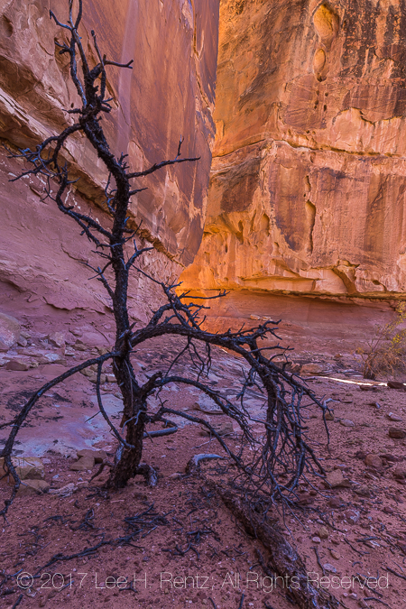
Dead tree among the colorful sandstone formations within Salt Creek Canyon
Here is a selection of other photographs from the trip. Double Click on one to see them larger and with captions.
Hand Print at Big Ruin, an Ancestral Pueblo village site within Salt Creek Canyon in The Needles District of Canyonlands National Park, Utah, USA
Scrapers made of chalcedony or a related quartz rock left by the Ancestral Puebloan people living at Big Ruin within Salt Creek Canyon in The Needles District of Canyonlands National Park, Utah, USA
Salt Creek, a perennial stream that is laden with fine sediment and bordered with algae, but is drinkable, within Upper Salt Creek Canyon in The Needles District of Canyonlands National Park, Utah, USA
Sandstone Formations near Big Ruin, an Ancestral Puebloan village site within Salt Creek Canyon in The Needles District of Canyonlands National Park, Utah, USA
Wedding Ring Arch within Salt Creek Canyon in The Needles District of Canyonlands National Park, Utah, USA
Desert varnish runs down the cliff above Big Ruin, an Ancestral Pueblo village site within Salt Creek Canyon in The Needles District of Canyonlands National Park, Utah, USA
Dry corncobs that are some 700 years old at Big Ruin, an Ancestral Pueblo village site within Salt Creek Canyon in The Needles District of Canyonlands National Park, Utah, USA
Karen Rentz with tall Rubber Rabbitbrush, Ericameria nauseoa, along the trail within Salt Creek Canyon in The Needles District of Canyonlands National Park, Utah, USA
Blue Gramma, Bouteloua gracilis, seed heads of a native grass growing within Salt Creek Canyon in The Needles District of Canyonlands National Park, Utah, USA
Fragile cryptobiotic soil crust within Salt Creek Canyon in The Needles District of Canyonlands National Park, Utah, USA
Shedded rattlesnake skin with potsherds left by the Ancestral Puebloan people living at Big Ruin within Salt Creek Canyon in The Needles District of Canyonlands National Park, Utah, USA
Sediment in water near campsites SC1 and SC2 within Salt Creek Canyon in The Needles District of Canyonlands National Park, Utah, USA
Mule Deer antlers used as a trophy decoration in Kirk’s Cabin in Salt Creek Canyon in The Needles District of Canyonlands National Park, Utah, USA
Yucca, Yucca spp., growing with sagebrush and cottonwoods along the trail through Salt Creek Canyon in The Needles District of Canyonlands National Park, Utah, USA
Ruins of a group of masonry structures made by the Ancestral Puebloan people some 700 years ago within Salt Creek Canyon in The Needles District of Canyonlands National Park, Utah, USA
Claretcup, Echinocereus triglochidiatus, forming a large mound of prickly cactus stems in Canyonlands National Park’s Salt Creek Canyon, Utah, USA
Mano and metate used for grinding corn some 700 years ago at Big Ruin, an Ancestral Pueblo village site within Salt Creek Canyon in The Needles District of Canyonlands National Park, Utah, USA
Potsherds in black-on-white style left by the Ancestral Puebloan people living at Big Ruin within Salt Creek Canyon in The Needles District of Canyonlands National Park, Utah, USA
Moonlight illuminating the rock formations, with the Milky Way in the sky, viewed from campsite within Salt Creek Canyon in The Needles District of Canyonlands National Park, Utah, USA
Ancestral Puebloan House with a Mule Deer, Odocoileus hemionus, antler within Salt Creek Canyon in The Needles District of Canyonlands National Park, Utah, USA
16°F morning at campsite within Salt Creek Canyon in The Needles District of Canyonlands National Park, Utah, USA
Trail winding through Prickly Pear Cactus within Salt Creek Canyon in The Needles District of Canyonlands National Park, Utah, USA
Sunset glow on sandstone formations, viewed from Camp SC3 within Salt Creek Canyon in The Needles District of Canyonlands National Park, Utah, USA
Ruins of masonry building created by Ancestral Puebloan people within Salt Creek Canyon in The Needles District of Canyonlands National Park, Utah, USA
Mule Deer, Odocoileus hemionus, antler dropped under Gambel Oak trees in Salt Creek Canyon in The Needles District of Canyonlands National Park, Utah, USA
Autumn Gambel Oak, Quercus gambelii, leaves and shadows within Salt Creek Canyon in The Needles District of Canyonlands National Park, Utah, USA
Starry, starry, night camping within Salt Creek Canyon in The Needles District of Canyonlands National Park, Utah, USA
Ancient pictographs created by the Ancestral Puebloan people within Salt Creek Canyon in The Needles District of Canyonlands National Park, Utah, USA
Fremont’s Cottonwood, Populus fremontii, turning gold in autumn, with the cooler tones of sagebrush and rabbitbrush, Salt Creek Canyon in The Needles District of Canyonlands National Park, Utah, USA
Kirk’s Cabin, built as a seasonal shelter by a rancher, with adzed logs and a fireplace, in Salt Creek Canyon in The Needles District of Canyonlands National Park, Utah, USA
Sunset glow on sandstone formations, viewed from Camp SC3 within Salt Creek Canyon in The Needles District of Canyonlands National Park, Utah, USA
Dead tree and night sky in campsite SC 1 in Salt Creek Canyon in The Needles District of Canyonlands National Park, Utah, USA
Dramatic Rock Formations in Salt Creek Canyon within The Needles District of Canyonlands National Park, Utah, USA
Squash plant that has persisted through reseeding for some 800 years, with a masonry granary once used by Ancestral Puebloan people within Salt Creek Canyon in The Needles District of Canyonlands National Park, Utah, USA
Prickly Pear Cactus, Opuntia sp., thriving in Salt Creek Canyon in The Needles District of Canyonlands National Park, Utah, USA
Handprints made over 800 years ago by Ancestral Puebloan people on the sandstone wallls of Salt Creek Canyon in The Needles District of Canyonlands National Park, Utah, USA
Old wood wagon wheel used for bringing in supplies to Kirk’s Cabin, an early ranching outpost, in Salt Creek Canyon in The Needles District of Canyonlands National Park, Utah, USA
Slickrock Landscape in Salt Creek Canyon in The Needles District of Canyonlands National Park, Utah, USA
Old wood wagon wheel used for bringing in supplies to Kirk’s Cabin, an early ranching outpost, in Salt Creek Canyon in The Needles District of Canyonlands National Park, Utah, USA
Backpackers resting under a rock overhang within Salt Creek Canyon in The Needles District of Canyonlands National Park, Utah, USA
Slickrock Landscape in Salt Creek Canyon in The Needles District of Canyonlands National Park, Utah, USA
Kirk’s Cabin, built as a seasonal shelter by a rancher, with adzed logs and a sandstone chimney, in Salt Creek Canyon in The Needles District of Canyonlands National Park, Utah, USA
Stylized pictograph, one of a group known as The Four Faces, created by an Ancestral Puebloan or Fremont artist, within Salt Creek Canyon in The Needles District of Canyonlands National Park, Utah, USA
Canyonlands National Park’s Salt Creek Canyon was a quiet place during our four day backpacking trip. In fact, we didn’t see anyone for 2 1/2 days during the hike, making it the perfect wilderness experience. It is a place suffused with remnants of the past, as well as spectacular slickrock formations and evidence of wildlife.
When we visited in October, we started out at the Cathedral Butte Trailhead and hiked in about as far as there was potable water. It is named Salt Creek for a reason: there are alkali salts suspended in the water that quickly clogged our filter, so we had to depend upon iodine tablets and boiling water in order to get drinkable water. No problem if you are prepared.
October was colder than we expected, with the three clear nights reaching down to 16°F, 13°F, and the last night at 11°F. Our down sleeping bags were perfect; don’t expect to be warm with summer-weight bags. The Milky Way and moonlight were wonderful in the canyon, and it was great to climb into the fluffy sleeping bag after our stargazing sessions.
Black Bears are frequently sighted in the canyon, so the National Park Service now requires that hikers carry bearproof canisters. What would the wilderness be without a few predators to make us wary?
Salt Creek Canyon is filled with evidence of prior inhabitants. Please, leave everything untouched so that our descendents can enjoy the magic of this spiritual place.
The National Park Service requires backpacking permits for Salt Creek Canyon, and there are four campsites that are assigned when hikers get their permits. Go to the Canyonlands National Park website for more information about the park and backpacking permits.
Among birders, the legend lives on of the Colima Warbler, found among oak trees in a remote canyon high in the Chisos Mountains of Big Bend National Park. The species is mostly found in Mexico, but this region of south Texas has a couple of places where birders can fairly reliably stalk it, and we decided to be warbler stalkers for a day.
Early that May morning, we laced up our hiking boots and smeared on SPF 55, anticipating a long day in the bright sun. The route would take us from the Chisos Basin, where we were camped, to Boot Canyon, about 3.5 miles distant, with a 2,000 foot elevation gain.
As usual, my intention of finding the Colima Warbler got sidetracked almost immediately, when we walked past a dead Havard Century Plant that was cheeping at me. Huh? I looked on the other side of the brown flowering stalk and discovered a perfectly round hole that was clearly a nest with hungry baby birds in it. So, I hunkered down in the dust and waited for a parent to come. It didn’t take long until a wary mother Ladder-backed Woodpecker showed up and ducked quickly into the hole, where it fed the nestlings.
Ladder-backed Woodpecker, Picoides scalaris, adult female servicing its young in a nest hole in a dead Havard Century Plant, Agave havardiana, flowering stalk, in the Chisos Mountains of Big Bend National Park, Texas
I was there a long time, and Karen had the opportunity to see a pair of Crissal Thrashers trying to thrash each other while waiting interminably for me to finish photographing. So she got a new species and I missed the opportunity entirely. Oh well, at least I got a few pictures of the woodpecker.
Next I got distracted by bugs, specifically some Giant Agave Bugs crawling around the tip of a rapidly growing Havard Century Plant stalk. Creepy? Yes. But I was amazed at the size of these creatures, which are in the scientific category known as “True Bugs.” Yes, that really is a category, though most real scientists would prefer to use the scientific name, Hemiptera, so that they don’t sound like 8-year-old boys with bug nets. These big bugs sip the sap of the century plant, though probably not enough to hurt it.
Giant Agave Bugs, Acanthocephala thomasi, on the expanding flower stalk of a Havard Century Plant, Agave havardiana, aka Havard Agave, in the Chisos Mountains. This stalk is probably over 3″ in diameter at the bottom
Onward and upward, we came upon our first Mexican Jays, which are loud and travel in gangs and aren’t very afraid of people. If Donald Trump was a birdwatcher, he would probably want to set up a wall, or at least a mist net, to stop these birds from entering the country. Though he might like their gaudy blue color and brash attitude. Seeing these jays was a first for us, as we climbed toward seeing 530 birds on our North American Life Lists.
Higher still, Karen spotted a Painted Redstart, in the oak and maple forest–another first for us and a stunningly beautiful bird. There were also Texas Madrone trees, similar to the Madrone trees of the west coast, but with minor differences that I apparently couldn’t see.
Over the pass with long views into Mexico. There were birdwatchers on their own journeys to see the famous Colima. There were also lots of backpackers heading up to campsites hidden all along the trails. It would be a beautiful place to backpack, except for the lack of water along the way, which means carrying the recommended one gallon of water (8+ lbs!) per person per day. That doesn’t leave a lot of room for camera equipment, but we all have our priorities. Would I rather photograph little birds or die of thirst in the desert? I’ll have to think about that one.
Mexican Jays, Aphelocoma ultramarina, foraging on the ground in the Chisos Mountains
Meanwhile, we finally reached Boot Canyon, where the Colima Warbler had been spotted earlier in the week. We stood around. We listened. We walked a few feet. We scanned the canyon with our binoculars. And … nothing. I’m pretty sure I heard the warbler, but not sure enough to count it on my all-important life list. After an hour or so, we gave up on this location, hoping beyond hope that it had simply wandered down the trail we were taking. It didn’t.
We decided that since we had come this far, we might as well complete the 10+ mile loop, rather than going back the way we came. I busied myself with photographing century plants and cactus, since they can’t fly away and hide, although I am paranoid about poking myself in the eye with a sharp spine, which makes me cringe at the thought even as I write this.
View down into desert from Boot Canyon Trail in the Chisos Mountains of Big Bend National Park
By the time we arrived back at the campground, our feet were aching and hot, and we were ready to rest. But that moment brought the best light of the day, with alpenglow or its desert equivalent lighting up Casa Grande with brilliant orange light. So I scurried around the campground trying to get the best angle on the iconic peak until I was bone tired.
We had “dipped” on the warbler: birdwatcher speak for not seeing a desirable bird that we had traveled miles to see, but it was still a great day.
Postscript: We arrived in El Paso late the next day, after passing through a fierce dust storm that sandblasted us with 60 mph winds and near zero visibility. With the temperature at 95 degrees F and the dust storm continuing, we wimped out and stayed in a motel rather than camping for the night. In the cool and quiet lobby of the motel, there was a birding tour group getting their final debriefing for their Texas trip by the trip leaders. It turned out that all these old birders (as in, anyone older than me!) had done the same hike we did, but with expert leadership, they had seen the Colima Warbler. I’ll be back and the punk warbler will make my day.
Gallery of hike photographs:
Texas Madrone, Arbutus, xalapensis, tree high in the Chisos Mountains, Big Bend National Park, Texas, USA
Curving trunk of a big oak tree in the Chisos Mountains of Big Bend National Park, Texas, USA
Succulent leaves of Havard Century Plant, Agave havardiana, aka Havard Agave, in the Chisos Mountains of Big Bend National Park, Texas, USA
Succulent leaves of Havard Century Plant, Agave havardiana, aka Havard Agave, in the Chisos Mountains of Big Bend National Park, Texas, USA
Scarlet Hedgehog Cactus, Echinocereus coccineus, blooming high in the Chisos Mountains of Big Bend National Park, Texas, USA
Iconic Casa Grande in the Chisos Mountains, viewed from the Laguna Meadow Trail in Big Bend National Park, Texas, USA
Succulent leaves of Havard Century Plant, Agave havardiana, aka Havard Agave, in the Chisos Mountains of Big Bend National Park, Texas, USA
Close-up view of Chisos Prickly Pear, Opuntia chisosensis, in the Chisos Mountains of Big Bend National Park, Texas, USA
Artistic bark detail of Texas Madrone, Arbutus, xalapensis, tree high in the Chisos Mountains, Big Bend National Park, Texas, USA
Succulent leaves of Havard Century Plant, Agave havardiana, aka Havard Agave, in the Chisos Mountains of Big Bend National Park, Texas, USA
Sign for Chisos Basin Loop Trail in the Chisos Mountains of Big Bend National Park, Texas, USA
Casa Grande and Chisos Basin Loop Trail in Big Bend National Park, Texas, USA
Mexican Black Bear, Ursus americanus eremicus, an endangered species; one cub of three accompanying mother in the Chisos Mountains of Big Bend National Park, Texas, USA
Dramatic sunset glow on iconic Casa Grande peak in the Chisos Mountains, viewed from Chisos Basin Campground, Big Bend National Park, Texas, USA
Dramatic sunset glow on iconic Casa Grande peak in the Chisos Mountains, viewed from Chisos Basin Campground, Big Bend National Park, Texas, USA
To see what the Colima Warbler is supposed to look like, go to Colima Warbler
For general information about visiting this stupendous national park, go to Big Bend National Park
Remember that Big Bend National Park is is the Chihuahuan Desert. If you go, make sure you plan your schedule to maximize your chance to see the warbler and other birds, and make sure to know the hazards of the desert ahead of time.
To see more of my work, read more of my blog entries here or go to my website Lee Rentz Photography.