A journal of the thoughts, pictures, and adventures of photographer and writer Lee H. Rentz. Inspired by nature, with a passion for ideas both visual and literary.
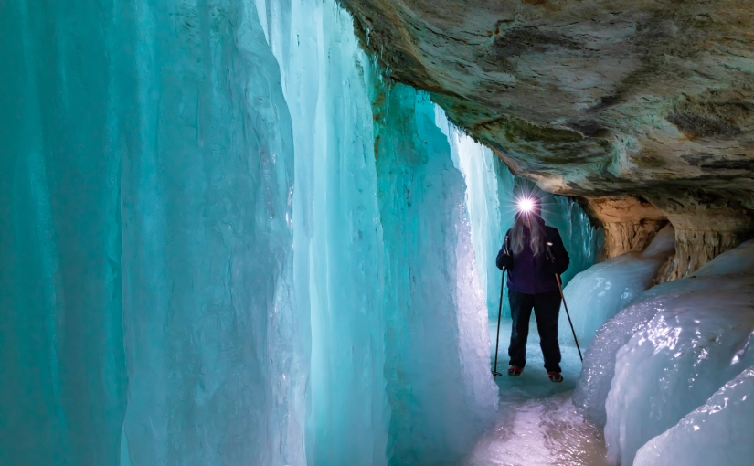
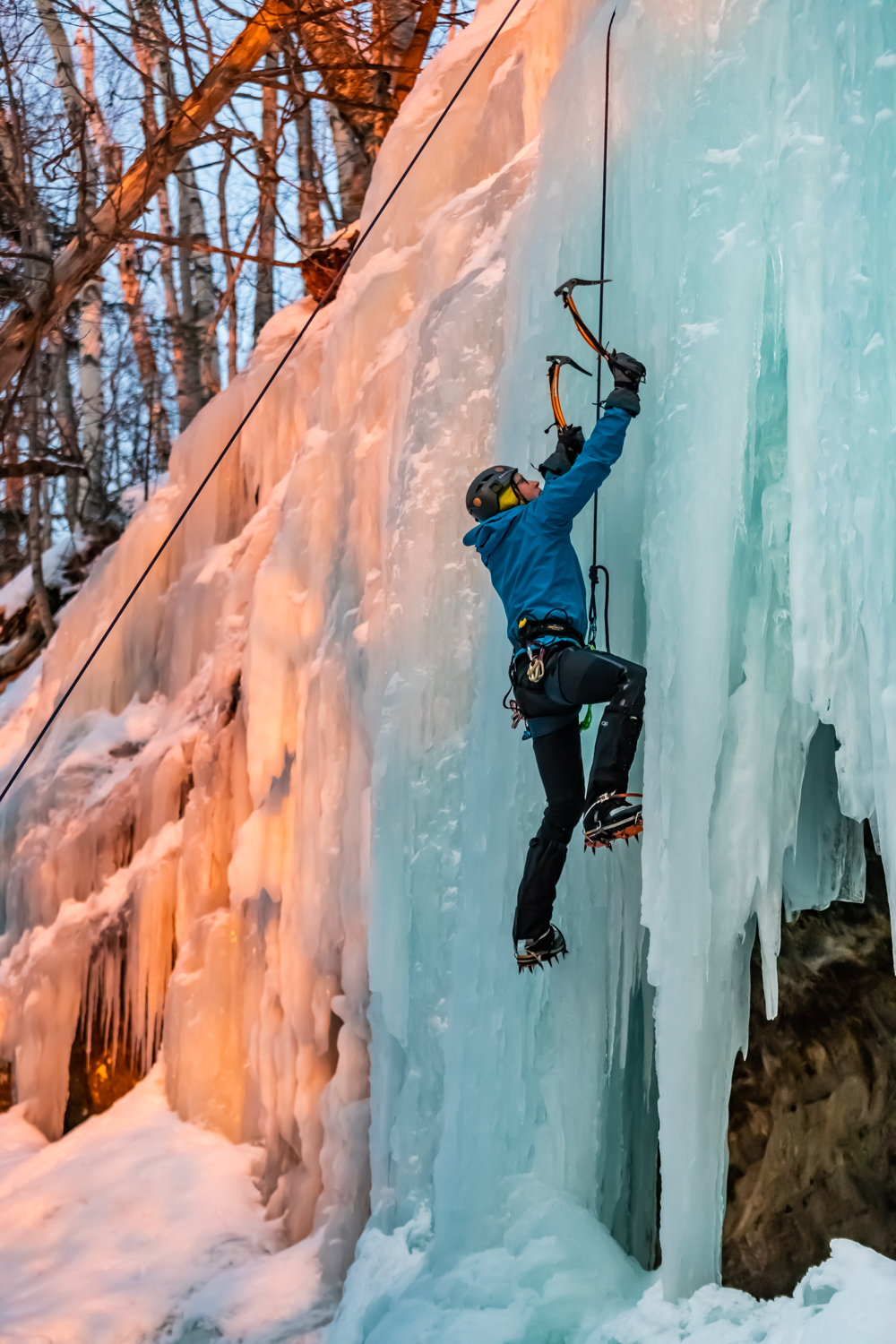
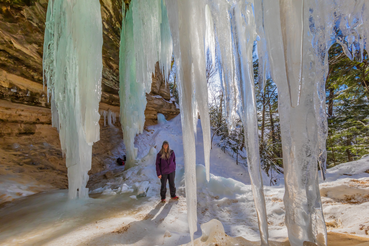
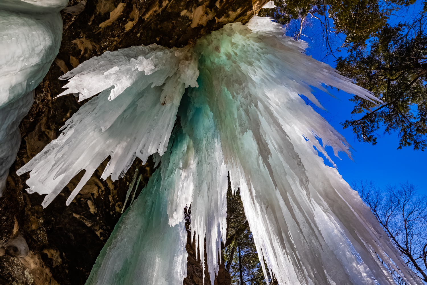
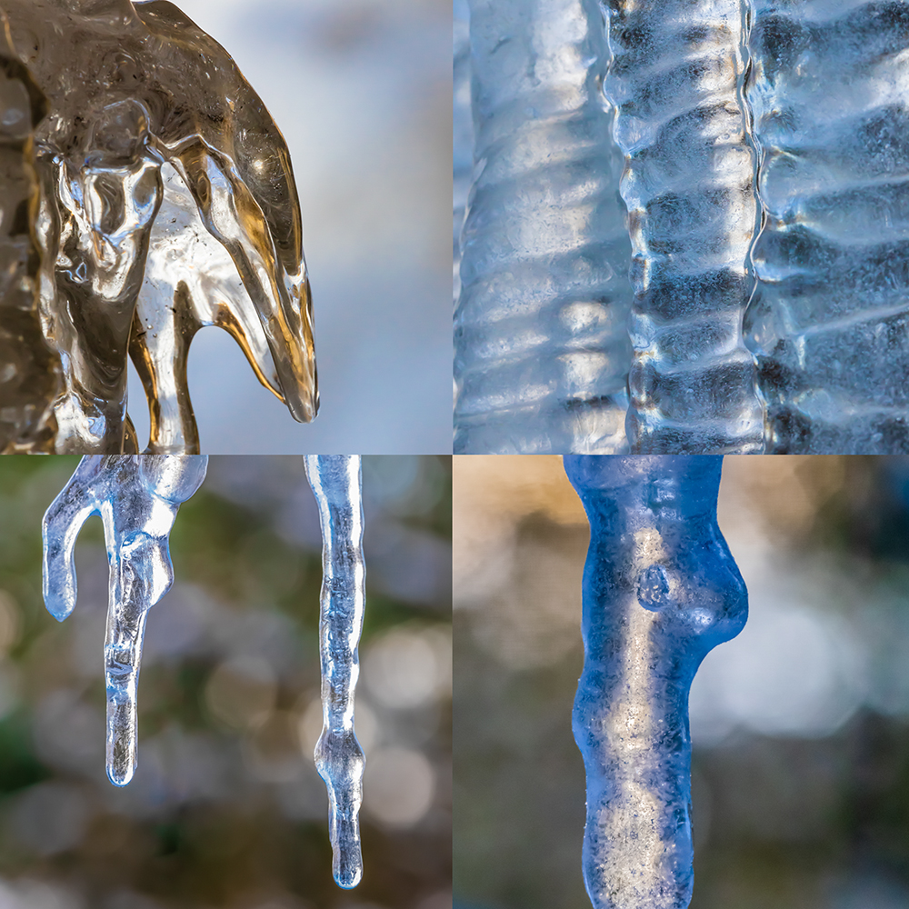
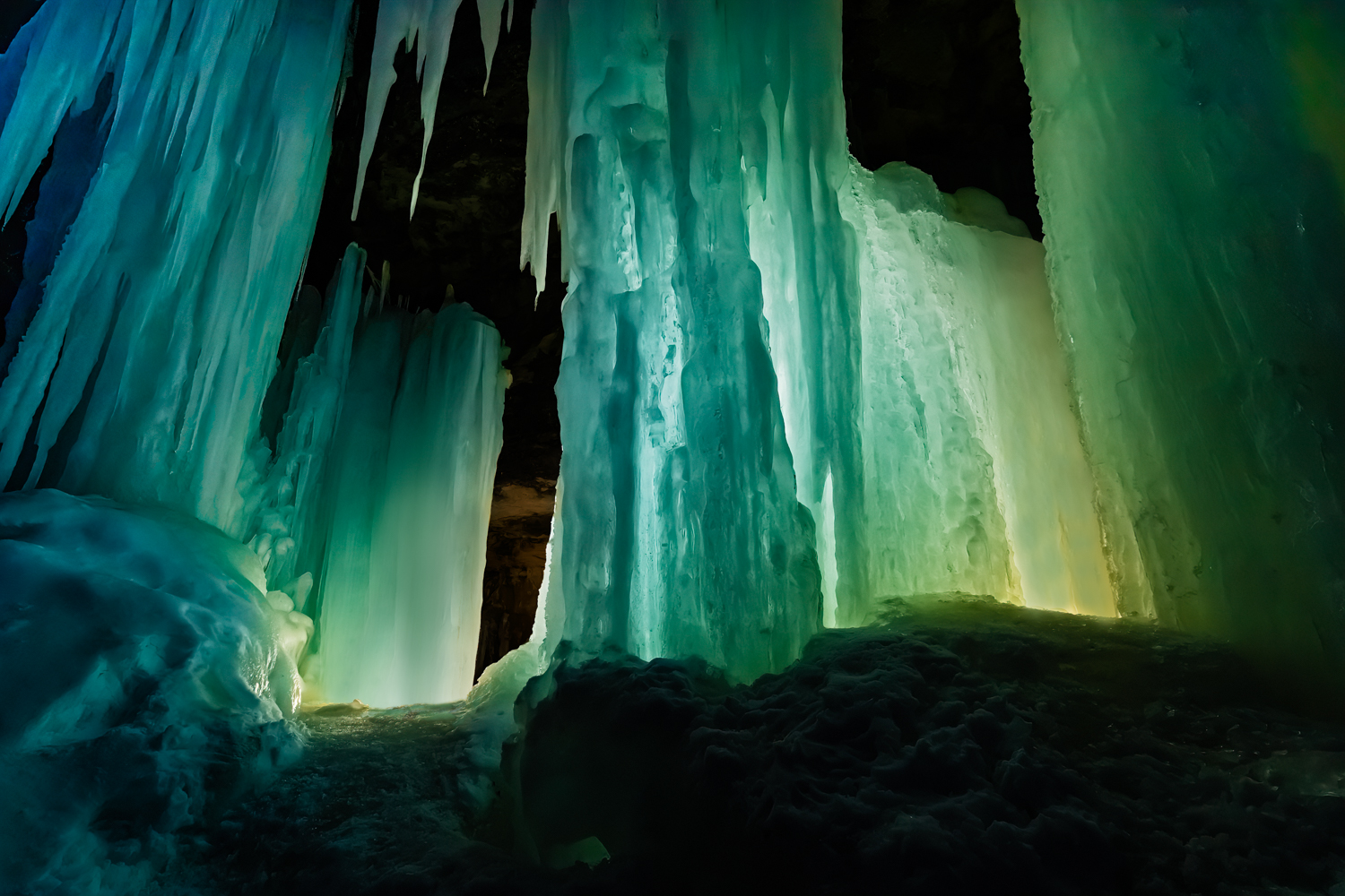
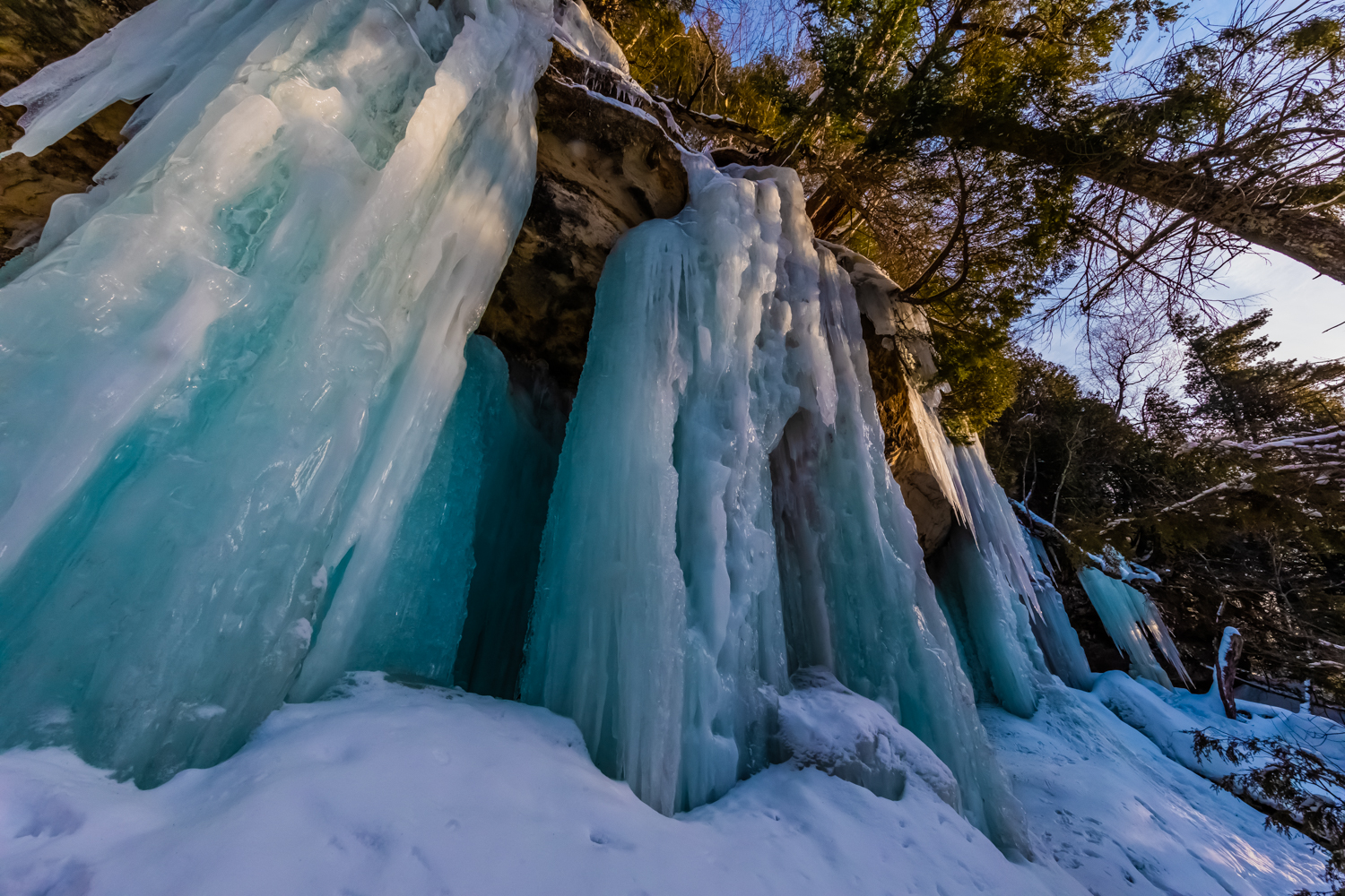
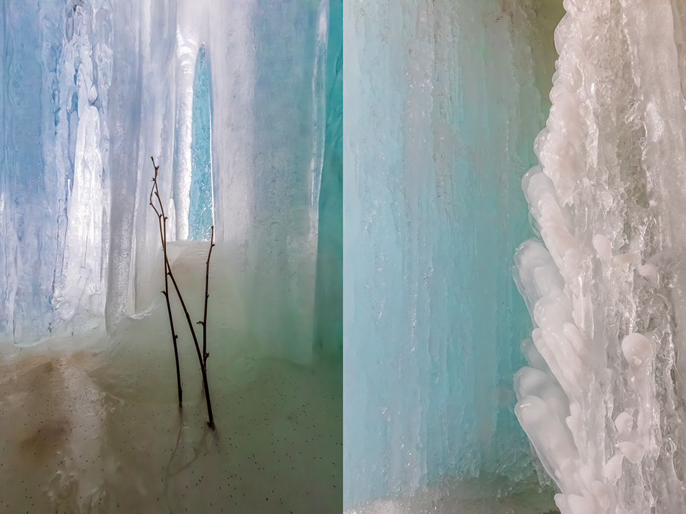
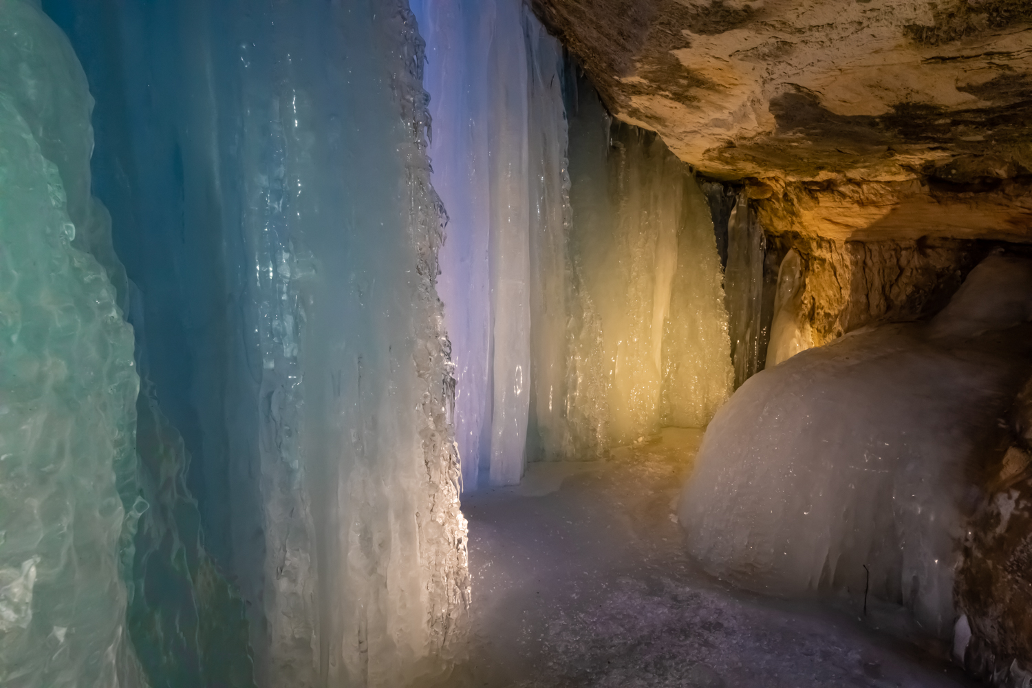
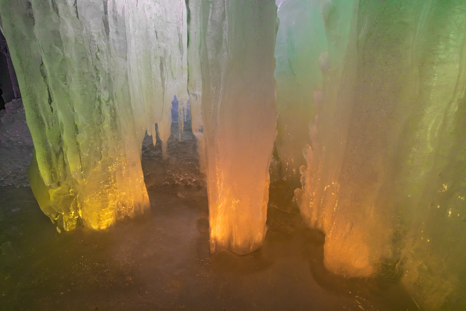
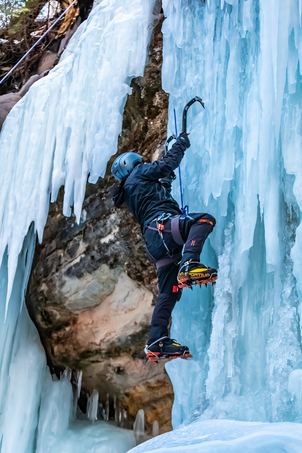
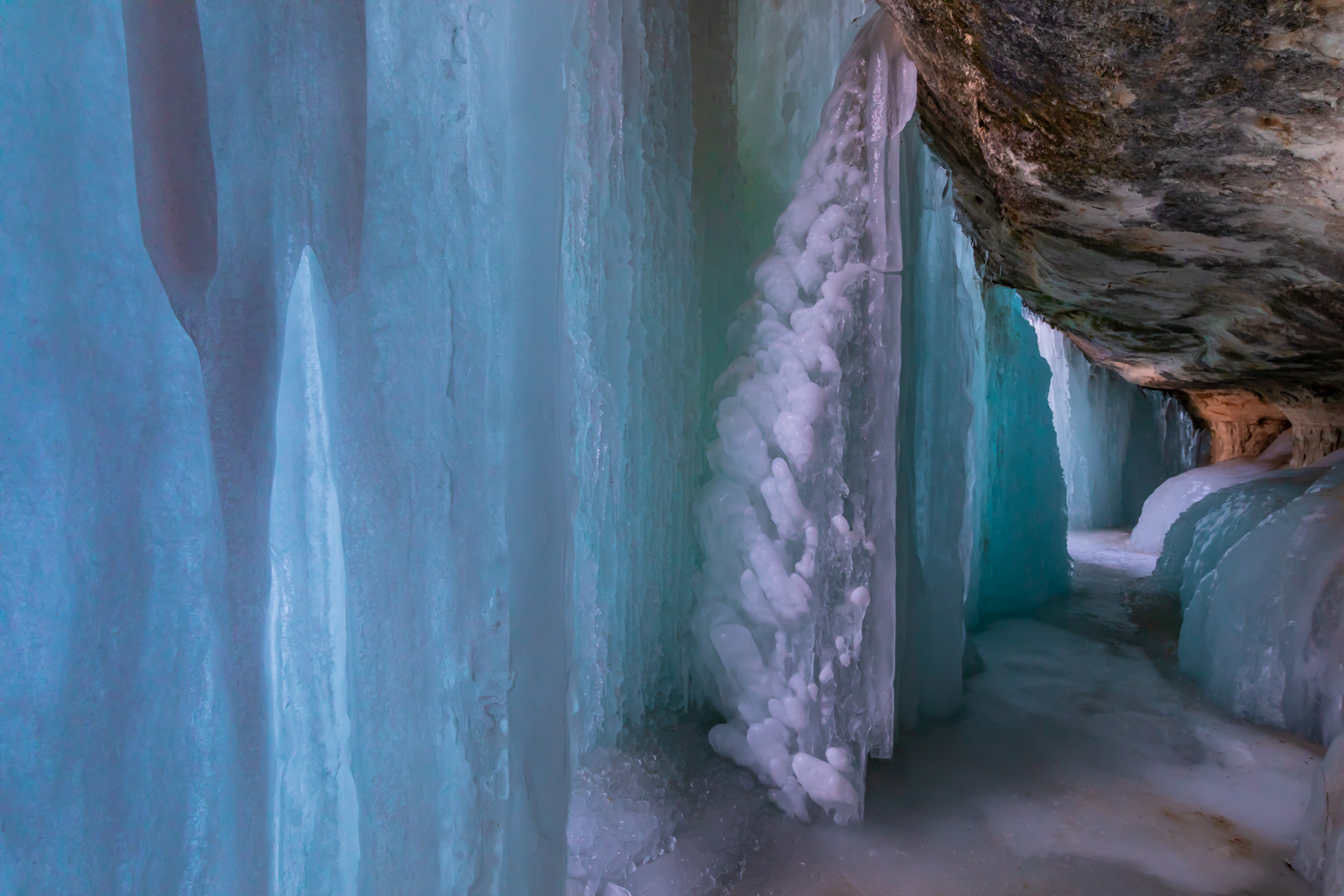
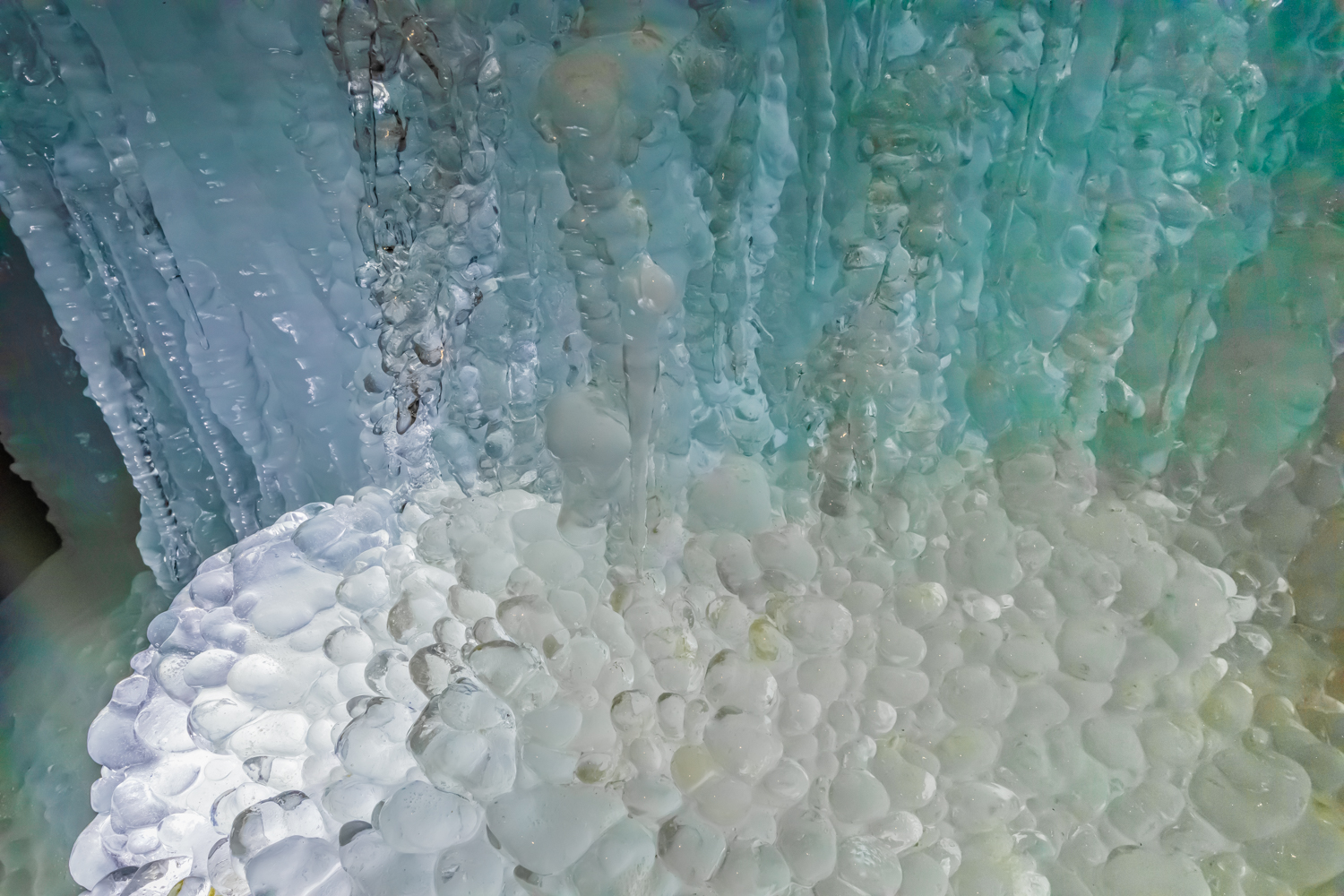
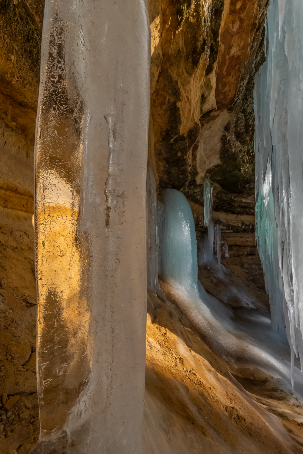
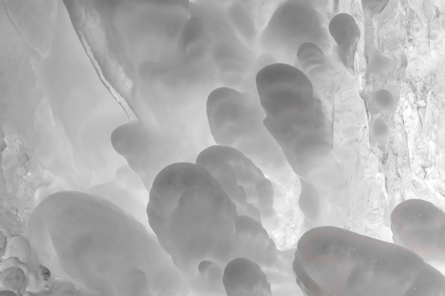
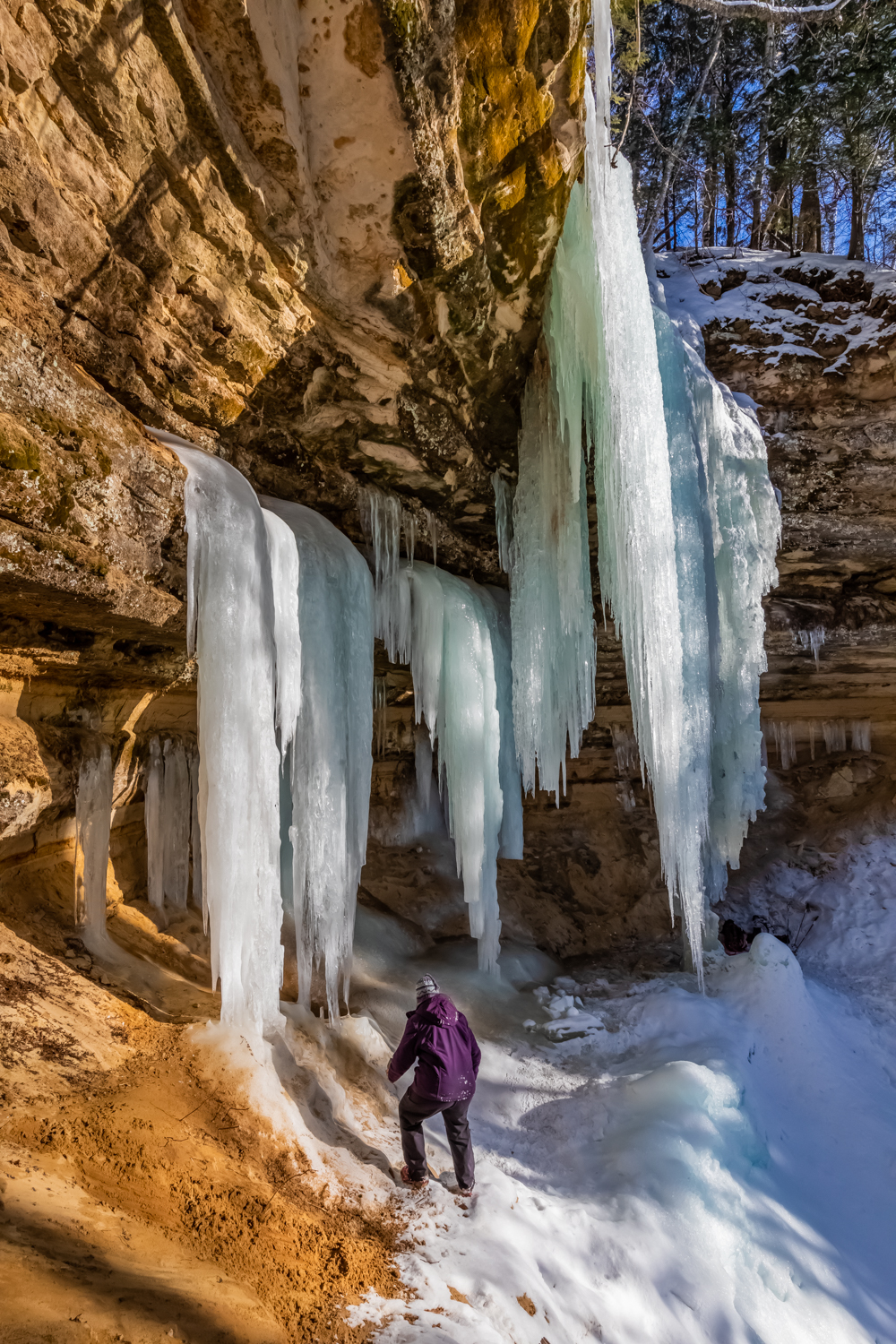
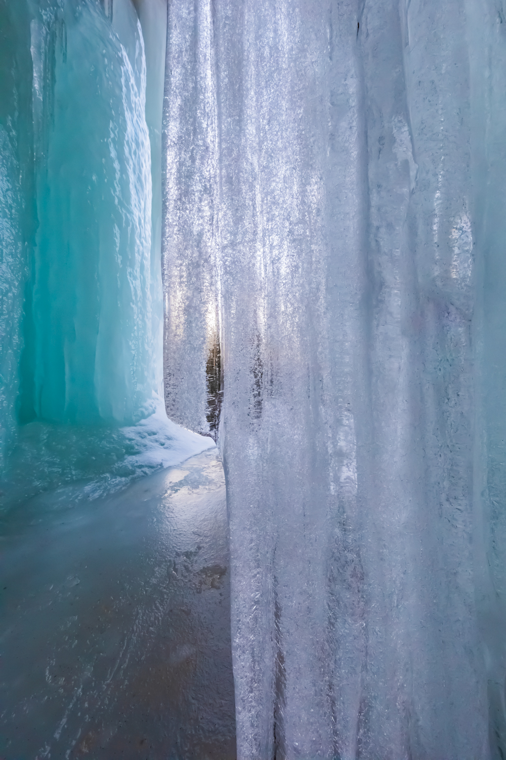
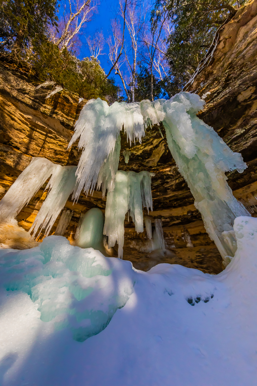
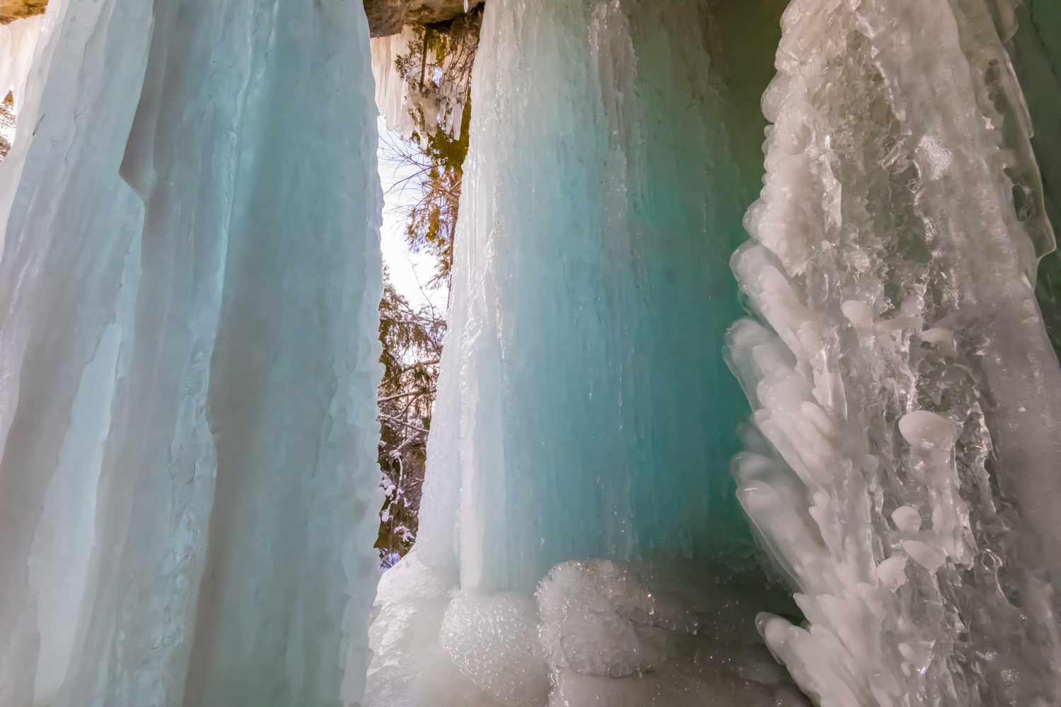
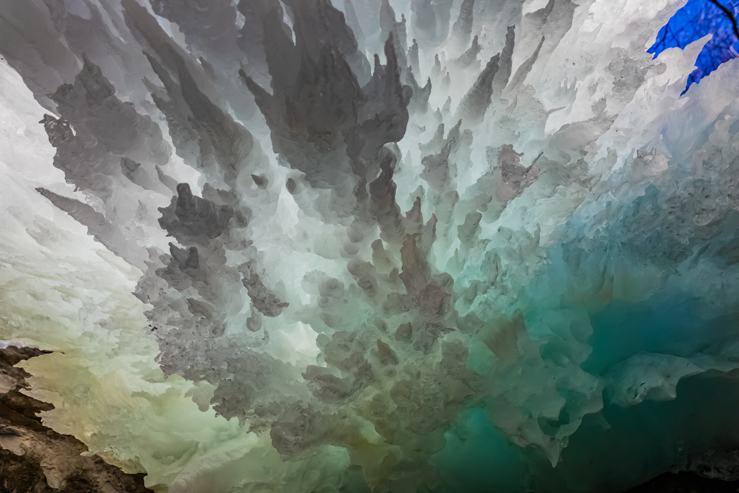
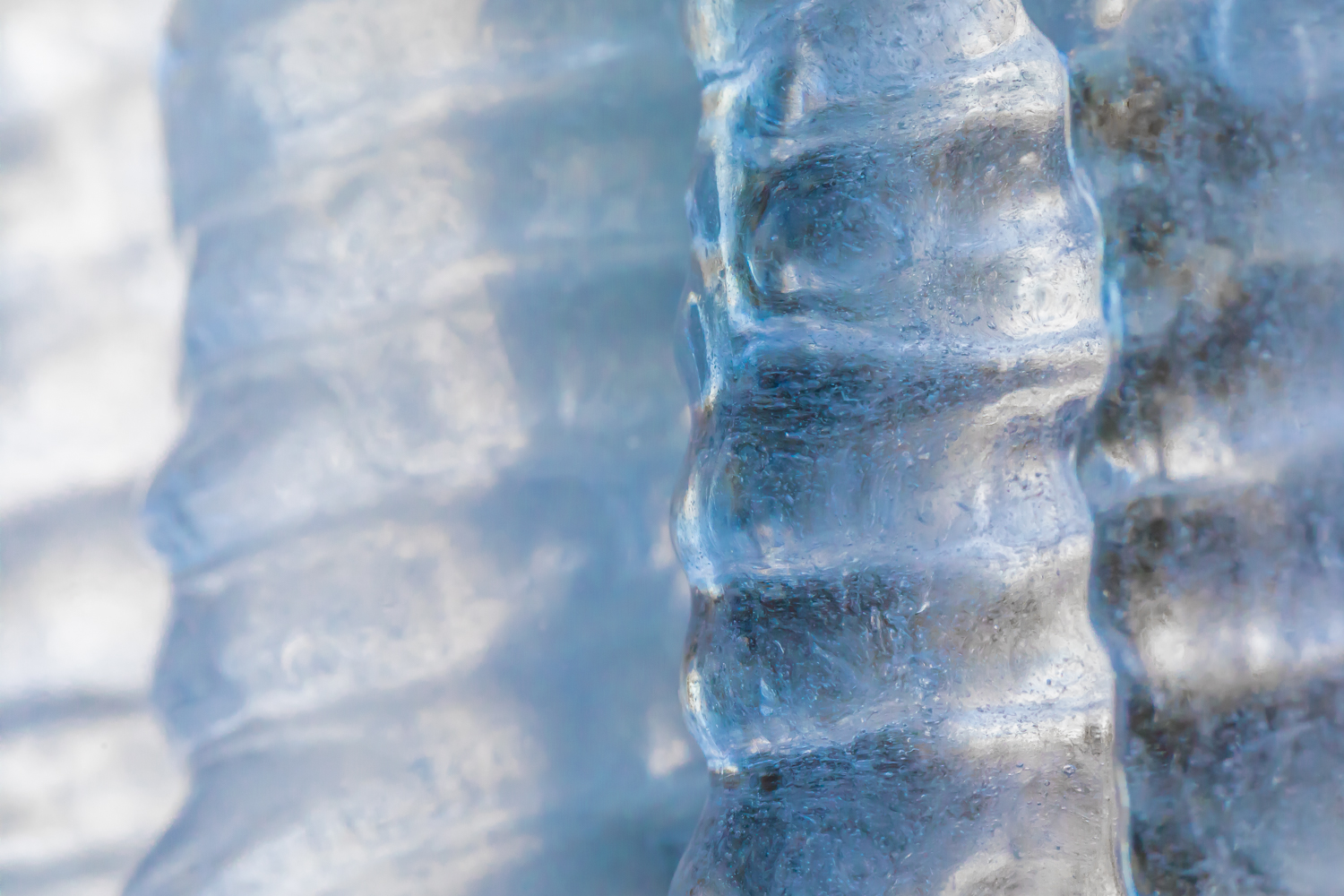
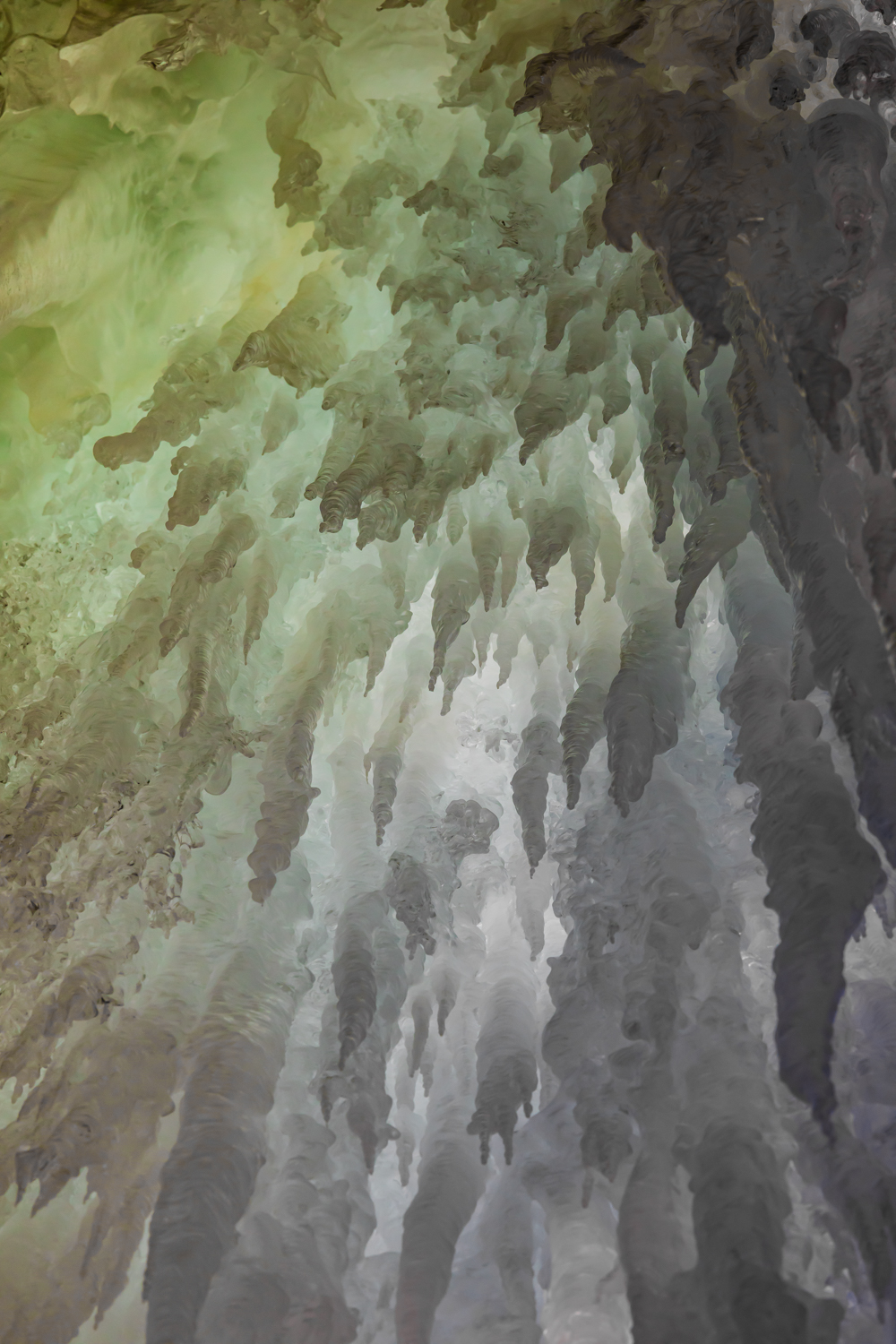
Each winter temporary ice formations form along the orange sandstone cliffs of Pictured Rocks National Lakeshore in Michigan’s Upper Peninsula. Wherever a tiny stream cascades over a cliff, or where water oozes through porous stone, ice forms upon hitting the frigid temperatures of a Lake Superior winter. These formations are reliable enough to have descriptive names given by the ice climbers who return each winter to test their skills on the frozen columns.
I have photographed the formations over several winters, but the winter of 2023 was my favorite because Karen (my wife) and I experimented with backlighting the ice at twilight and at night to give a sense of the color and translucency of the beautiful formations. I find the natural artistry of the ice as stunning as the sandstone formations of the Utah desert, but these are ephemeral and have to recreate themselves each winter. What an experience!
Ice climbing on Curtainsat sunseKaren Rentz at Amphitheater ice formation, with ice daggers overheadAmphitheater ice formationDetails of ice formations in Pictured Rocks National LakeshoreCurtains ice formation lighted by us at nightCurtains ice formation at the end of a winter dayTwo views of naturally sculpted ice behind the CurtainsBehind the Curtains ice formation, lit by the photographer’s lights and by the twilight outsideIce Daggers of the Amphitheater formationCurtains ice formation lighted at nightIce climbing on Curtains; note the ice tools, rope, helmet, and cramponsNorthern White Cedar twigs encased in ice in the Curtains ice formationBehind the Curtains ice formation with blue twilight coloring the translucent iceDetails of Curtains ice formation lighted at night; the round bubble-like shapes are created by water drops melting from the ice column aboveLate afternoon light on the Amphitheater ice formationSculptural details of the Curtains ice formation lighted at nightKaren Rentz at Amphitheater ice formation: the ice columns emerge from seeps in the sandstoneKaren Rentz exploring behind the Curtains ice formationBehind the Curtains ice formation, the translucent ice is reminiscent of a bridal veilFront view of Amphitheater ice formation named for the shape of the alcove in the cliffsDetails of Curtains ice formation; note how the ice takes different shapesDetails of Curtains ice formation lighted at nightAmphitheater ice formation used by ice climbers in Pictured Rocks National LakeshoreIcicle details of the Curtains ice formationDagger icicle details of the Amphitheater ice formation
Pictured Rocks National Lakeshore is located along Lake Superior in Michigan’s Upper Peninsula. Its namesake cliffs are miles long and make for great adventures all year, whether kayaking, backpacking, day hiking, snowmobiling, snowshoeing, cross-country skiing, or taking a guided cruise past the cliffs at sunset.
When we go in winter, we wear Kahtoola MICROspikes when navigating sheer ice at the ice formations, and we watched many people trying to stay upright when they walked in regular snow boots. Wear them! We also take snowshoes in case there has been a fresh snowfall and the trails are buried in deep fluff, though the short trails from Sand Point Road are often packed down by climbers. We also take cross-country skis to use on the nearby groomed trails. When venturing out in winter, we always wear insulated boots, and dress in layers of merino wool long underwear, waterproof snow/rain pants, and down, fleece, and a Gore-Tex shell. Mittens are essential, and chemical handwarmers can help when it’s really cold out. Take high energy snacks. To us, navigating winter is far more rewarding than enduring the bugs of early summer in the Upper Peninsula; just be prepared.
Important information about Pictured Rocks National Lakeshore:
Fishing stages and colorful homes in Francois during a snowstorm
The first leg of the journey was the drive to Burgeo, a fishing village accessed by Route 480 from the Trans-Canada Highway near Stephenville. The wild and beautiful landscape was covered with deep snow, and the conifers were magically encrusted with a thick layer of hard snow so that, in places, they looked like snow elves. We kept our eyes alert for Woodland Caribou, but didn’t see any on the drive. When we reached Burgeo, we stayed at a small motel that would be convenient for catching a ferry the next morning.
View of colorful houses across rocky bay from Sandbanks Provincial Park in Burgeo, Newfoundland
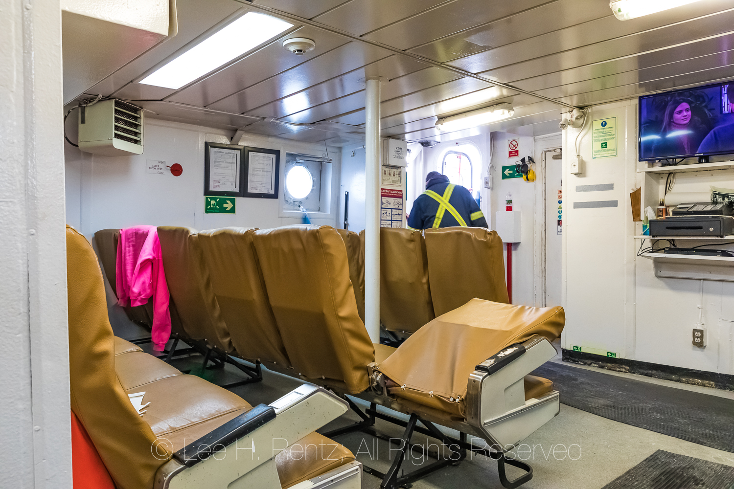
We packed what we would need for the trip in two suitcases and left the rest in the car, since we couldn’t take a car on the Marine Voyager ferry. These communities have no roads and no cars, so all that is needed is a foot ferry, albeit one that can carry enough cargo to meet a small community’s daily needs. We walked up the ramp on the ice-covered boat, then descended into a room for the passengers. Comfortable seats, round portholes, and a soap opera on the television – what more could we hope for? We paid our fee of $6 per passenger, which was clearly subsidized by the government, and settled in for our sailing along the coast.
Karen Rentz on ferry Marine Voyager, which takes foot passengers and cargo between Burgeo and the outports of Grey River and Francois, leaving the dock in Burgeo, Newfoundland, Canada
Captain steering Ferry Marine Voyager, which takes foot passengers and cargo between Burgeo and the outports of Grey River and Francois, leaving the dock in Burgeo
Passenger cabin interior on ferry Marine Voyager
There were only a couple of other passengers, and they lived in the villages of Grey River and Francois (a French name Newfoundlandized to “Fran-Sway.”) We were invited up to the bridge for a front-row seat and visit with the captain, who was a lifelong resident of Francois. One of the other passengers, a younger man named Cody who owned a fishing boat, introduced himself to us as well. He was also a lifelong resident of Francois and he told us about the community and what he liked about living there.
Hesitantly we asked the captain if he thought the ferry would be running two days later when we wanted to make our return trip, which would give us enough time to drive back to St. John’s and catch our flight back to the USA. He said this was the first time the boat had sailed for a week because of storms but that the weather looked good for our return trip. We had two nights at Francois and could enjoy ourselves. We had been watching the marine forecast every day for the past two weeks of our trip, trying to find a three-day window of weather when the ferry would be running; there were high winds and high seas every day and then finally the forecast looked good.
Waterfront with floating pancake ice at the outport of Grey River, which is snuggled along a fjord, viewed from the ferry Marine Voyager
The south coast of Newfoundland has a series of fjords, which provide sheltered locations and harbors for fishing communities. The village of Grey River was the first village we came to, and was located partway up a fjord. We motored through pancake ice and past colorful houses to the dock, where about ten people were waiting for the boat. All these people helped unload bread and beer and Amazon boxes full of the stuff a small community needs. Snowmobiles and ATVs were the transportation in town.
Unloading and transporting cargo at the outport of Grey River, which is snuggled along a fjord, viewed from the ferry Marine Voyager
Transporting cargo from dock to store by ATV at the outport of Grey River
Waterfront with glaze of sea ice at the outport of Grey River
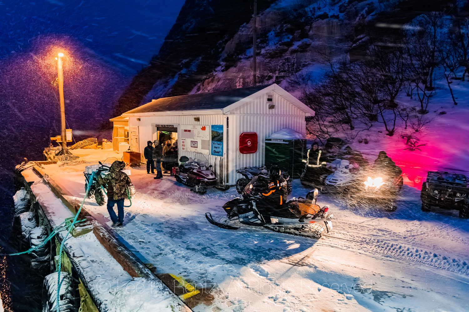
We soon set sail again, with no new passengers – after all, who would go from Grey River to Francois in the middle of winter? The sea was rough and it started to snow, and was just about dark when we carefully navigated the narrow fjord that ends at Francois. By this time the wind was howling and the driven snow stung our exposed faces. We didn’t know where our rental place was, but the captain and another man showed us the way and took our bags for us on a snowmobile. We settled into our place for two nights, and ventured outside briefly to get a feeling for the town.
Snowstorm at night when the ferry Marine Voyager reached the outport village of Francois
Snowstorm when ferry Marine Voyager reached the public dock in the outport village of Francois, transportation of cargo by snowmobile and ATV
Karen Rentz in snowstorm at night when the ferry Marine Voyager reached Francois
Snowstorm when ferry Marine Voyager reached the public dock in Francois
We spent the next day wandering the village along its boardwalks and pathways – remember, there are no roads needed in a town with no cars or trucks. All the houses are connected by these paths. The town is small, but has Sharon’s Place, a grocery and liquor store that is open morning, afternoon, and evening, with breaks for lunch and supper. There is a church that sits above the rest of town, and a large school that currently has six students and one-and-a-half teachers. This must be one of the smallest schools in the world in terms of the number of students! But education also arrives by computer, with courses available to older students online. There is a medical clinic, but no permanent doctor in town. There is a helipad used during emergencies.
Colorful houses and fishing stages in Francois
Wooden community sidewalk in Francois, a place with no roads
Colorful houses are a feature of the town, with red and purple and turquoise tones mixed together in a delightful jumble. In winter some are occupied and some are not, with some people leaving for part of the year for jobs. There are stages along the waterfront: small buildings on stilts where fishermen stored gear and later processed the catch. These are a distinctive and wonderful feature of all the Newfoundland coastal towns.
Colorful houses and fishing stages in Francois
Colorful houses and stages along the fjord containing Francois
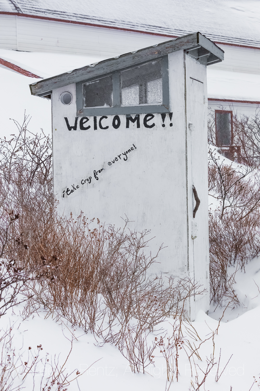
Public outhouse in Francois, with the slogan “I take crap from everyone!”
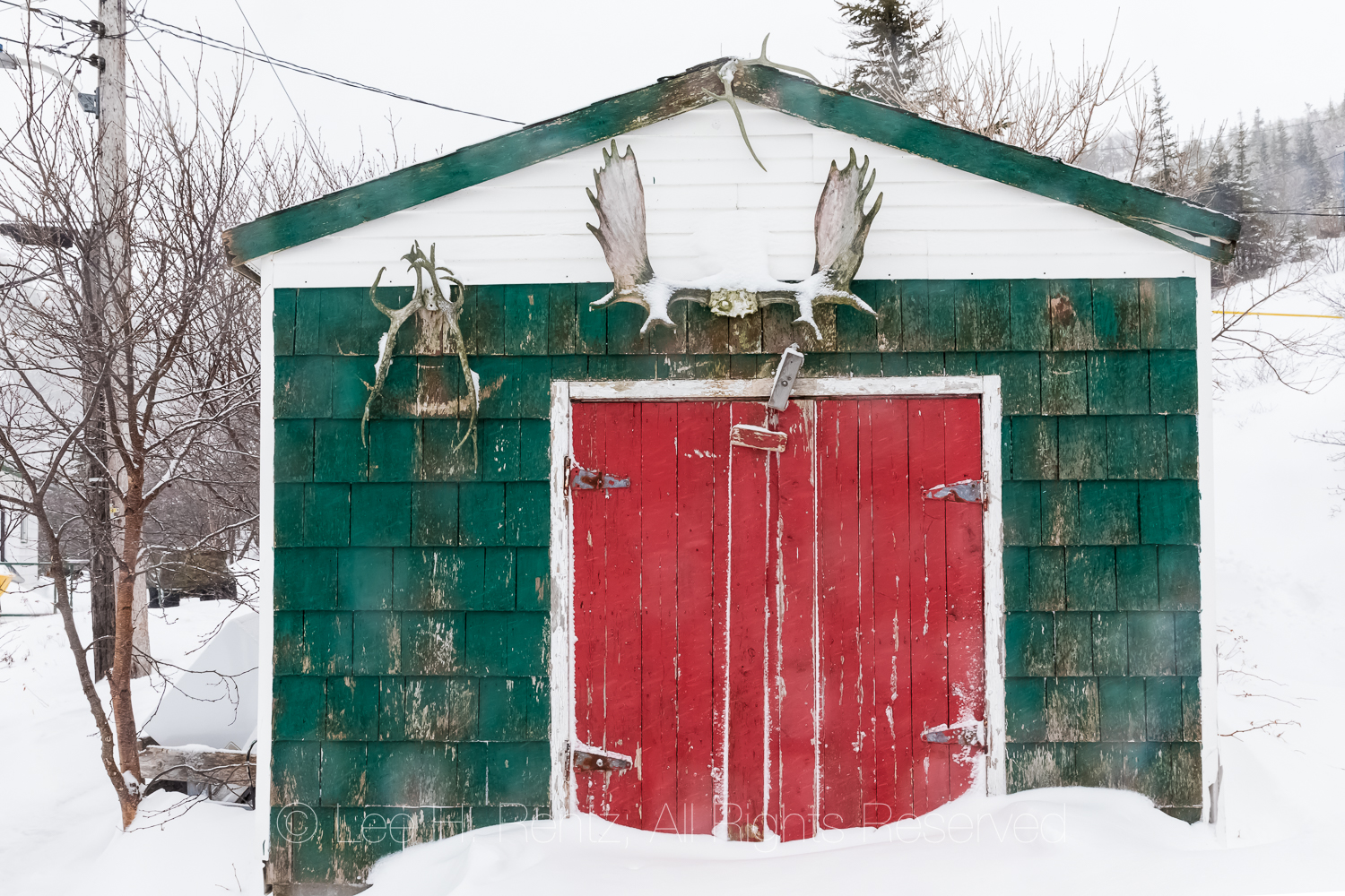
Shed with Moose and Caribou antlers in Francois
Fishing stage window with fishing ropes coiled inside along waterfront in Francois
Cleat and rope for docking in Francois
We walked past one house just as a lady in perhaps her late 70s was leaving the house on this snowy morning to meet for morning coffee with two other ladies who were 84 and 85 years old. We spoke with her briefly, and she told us she had lived her entire life in Francois. There were 89 people living in this little town in 2016, and we met perhaps eight of them – all of whom had lived here nearly their entire lives, except for time spent in the military or going to school. This lady was really concerned about the dwindling population of Francois.
As the snow continued to fall, we met up again with Cody from yesterday’s boat ride when he drove up on his Ski-Doo (the Newfoundland name for all snow machines) and chatted with him about the town. After graduating from the town’s school, the St. Simon & St. Jude Academy, he went to work on his father’s fishing boat. Later, he bought his own boat and now fishes for crabs, lobster, scallops, and sea cucumbers with his wife and up to five crew members.
Cody, a fisherman who has lived his whole life in Francois, and now owns his own boat harvesting scallops, lobster, crabs, and sea cucumbers
Fishing boat along colorful waterfront in Francois
Fishing gear on a boat in Francois
Fishing boat along colorful waterfront in Francois
Red building with firewood, crab traps, and a high birdhouse
Colorful houses and fishing stages in Francois
Colorful houses and fishing stages in Francois during a heavy snowstorm
Ski-Doo operator transporting stuff on a trailer on the wooden sidewalk in Francois
Fishing stages in Francois
Old fishing stage in Francois, where gear is kept, bait prepared, and fish cleaned
Cody’s diverse fishing activity is a big change from the past, when the fishery was based upon the seemingly never-ending cod supplies. Alas, every time people think that a natural resource is unlimited, they use it up, and Newfoundland’s fishery was no exception. It was devastated by overfishing of the once common cod, a harvest made possible by technological advances utilized by both Canadian and foreign companies. In July 1992, with cod stocks down to less than 1% of historic levels, the Canadian government abruptly shut down the 500-year old cod fishery in order to try and save the fish. This instantly put 30,000 Newfoundlanders out of work and devastated local communities. In the years since some, like Cody, were able to diversify and found a path to the future. Others found a future in tourism, which is starting to take off in Newfoundland. The cod has since rebounded but the fishery is extremely small and limited compared to the good old days. Just try to get fresh cod in Newfoundland most of the year!
A bit later we ran into another man on the boardwalk who was driving his Ski-Doo. He stopped to talk and told us that he was also a lifelong resident, but he didn’t make his living on the open ocean. He was a helicopter pilot who had worked for the Canadian Coast Guard, but now owns his own company and ferries a lot of people on remote hunting trips, mostly for Moose.
Ski-Doo operators meeting on the wooden sidewalk in Francois
Sharon’s Place, a general store, liquor store, and gathering place, with snowmobiles in Francois
Sign on St. Simon-St. Jude Academy, the public school, saying “A Clean Town is a Happy Town”
As I mentioned, the houses are scattered all around town seemingly randomly, with no clear lot boundaries. We asked one man about this, and he said that all the houses are built on Crown land, which is government land. People own their houses, but not the land under them.
We met another man driving his Ski-Doo who we had seen shoveling snow off a boat, which turned out to be his uncle’s boat. He works fishing for herring, crabs, lobster, and sea cucumbers. He was also a lifelong resident … are we beginning to see a pattern here? People are born here and live their whole lives here, though with a strong tether by ferry and by the internet and television to the larger world. When we asked Cody about his fellow citizens, he said that most everyone gets along well in town, but over time some people are moving away and the population is getting smaller.
Fishing stages in Francois during a heavy snowstorm
Fishing stage and colorful homes in Francois during a snowstorm
Fishing stages and colorful homes in Francois
Fishing stage, where gear is kept and equipment maintained and bait prepared
Fishing boat in Francois during a snowstorm
Crab pots and boat on a dock in Francois
The province of Newfoundland and Labrador has had a decades-long effort to move people away from the outports, which require huge government subsidies for ferry and helicopter transportation and education and medical care. By now, most Newfoundland outports have been abandoned, with the people voting to disband their towns and move elsewhere, but Grey River and Francois have been exceptions. In Francois, the question has come up for a vote twice over the years, but both times it was defeated (the latest in 2013) and the people remained. I understood that if the people voted to move out, the government would pay each homeowner $250,000 to compensate for the abandoned homes. It still could happen, but it is wonderful to see a few of the outports still hanging on against the tide of modernization.
I continued to photograph the buildings and waterfront and falling snow to my heart’s content on this wonderful day, when we talked to more strangers than we usually talk to in a week. Newfoundlanders are like that … they go out of their way to make visitors feel welcome, and we did.
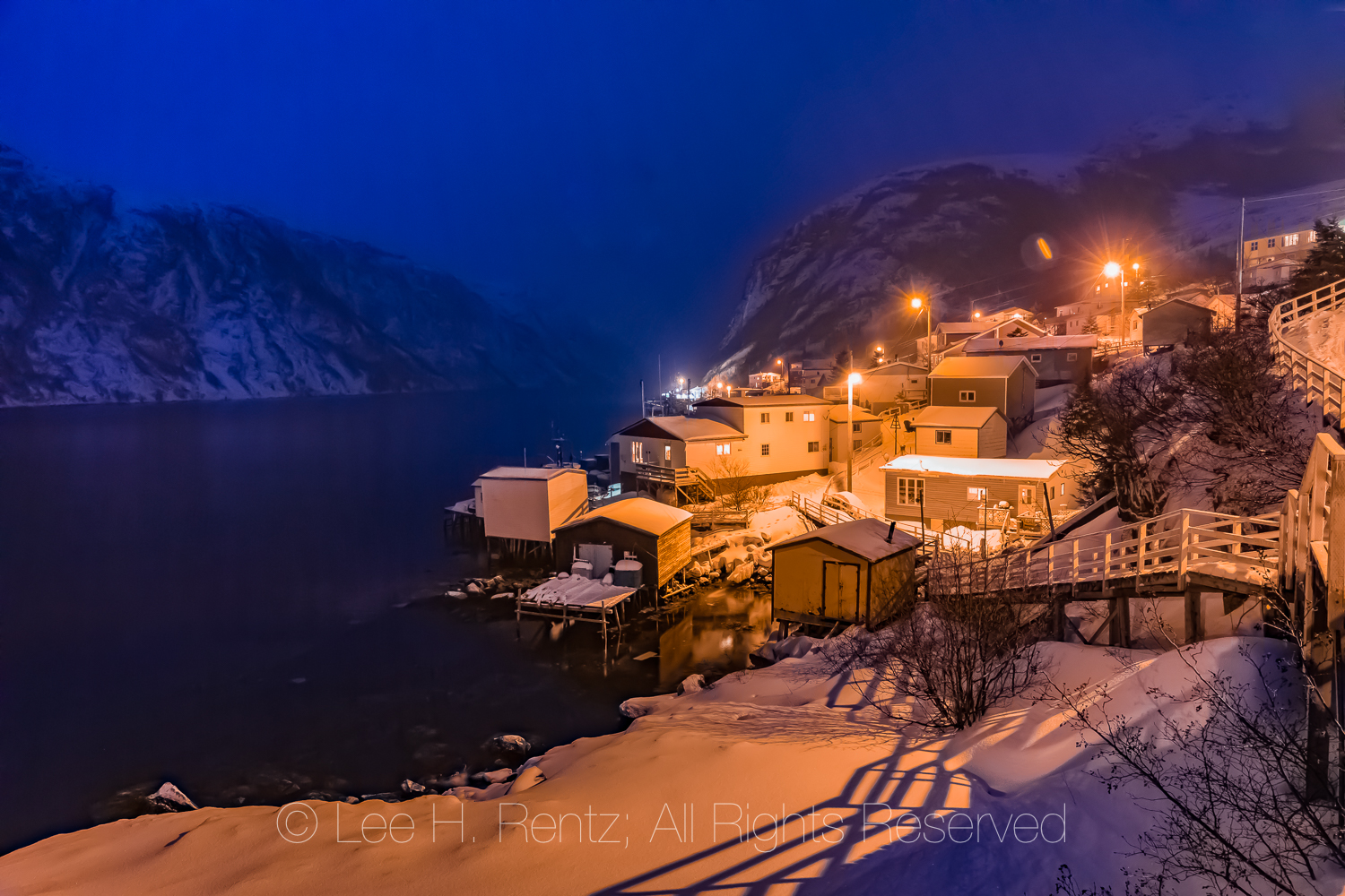
Francois at blue hour twilight
Francois at blue hour twilight along a fjord with mountain towering above
Francois, at blue hour twilight with lights reflecting off the fjord
Colorful homes in Francois
There is even a good story that might be mostly true or wholly true about a German submarine that entered the fjord containing Francois during World War II. It came to quietly get fresh water for its tanks at a waterfall entering the sea. It was on a Saturday night and there was a dance at the community center in town; some handsome but unknown young men showed up who knew little English and who danced the night away with the local girls. The young women apparently thought that these might be Basque fishermen who often fished nearby, and didn’t realize that the men were German sailors.
Francois Bay in early morning from the ferry Marine Voyager, after leaving the quaint outport of Francois in Newfoundland
Francois Bay in morning light
West Point Light Tower at mouth of Francois Bay viewed in winter morning light from the ferry Marine Voyager
Ferry Marine Voyager smashing into waves on the open ocean between the outports of Francois and Grey River in Newfoundland
Ferry Marine Voyager smashing into waves on the open ocean between the outports of Francois and Grey River in Newfoundland
Waves from ferry Marine Voyager distorting mountain reflections in the fjord leading to the outport of Grey River
Ferry Marine Voyager passing the colorful houses and sea ice at the outport of Grey River
Ferry Marine Voyager passing mouth of the fjord leading to the outport of Grey River
Bridge and wheel on Ferry Marine Voyager near Burgeo
The next morning we prepared to leave Francois for the voyage back, and the ferry Captain came to retrieve us. The morning showed a bit of sun and good weather for an ocean trip, so we went down to the dock and prepared to leave. The trip back was stunningly beautiful, with morning sun kissing the snow-covered headlands. And we got back in time to make the long drive to St. John’s to catch our flight.
Arriving in Burgeo from Francois and Grey River outports in Newfoundland, Canada
To view more of the photographic work by Lee Rentz, go to leerentz.com, where you can see thousands of photographs and purchase a special one for your walls.
We hiked to Shi Shi Beach and Point of Arches in Olympic National Park during the lowest tides of the year so we could explore the most distant tide pools. This experience never ceases to amaze us, and we see life forms that look like they evolved on another planet. This weblog primarily shows the hike through photographs, with a few words about our observations during our three-day backpacking trip in June 2018.
Point of Arches rocks at sunset
Shi Shi Beach was not as crowded as we expected, though by Saturday night it was pretty much filled up with people at the end near Point of Arches.
Almost all the people on the beach were millennials in their 20s, with few baby boomers until we saw some coming in on Sunday. Nice to see young people visiting. Everyone had smiles on their faces: exploring tidepools, photographing the sunset with smart phones, doing paired yoga poses, playing frisbee, and talking around campfires.
Perfect sunny weather; not too hot or cold.
Birdsong: lovely sounds of Swainson’s Thrush, Wilson’s Warbler, American Robin, Pacific Slope Flycatcher, and Pacific Wren floating above our tents. Pigeon Guillemot, Black Oystercatchers, gulls, ravens, eagles, and crows added their less musical but still atmospheric calls to the beach.
We waded through tide pools and climbed over barnacle- and mussel-covered rocks to get out to the outermost sea stacks. Getting near, we spotted a family (mother and two pups) of River Otters climbing the steep vegetated wall of a sea stack. A seabird was loudly calling out in alarm. Then, a pup fell 15′ down the cliff. The mother quickly descended with the other pup, dragging it along by the neck. When it got to the bottom, the mother rejoined the apparently uninjured pup, and then grabbed one of the pups by the neck and kept it from heading toward the sea. They quickly headed through one of the arches and we didn’t see them again. We could see their tracks where they explored the sea caves and arches. It’s good that the youngster had a resilient body; I would have been a heap of broken bones.
We spotted at least two Pigeon Guillemots high on the cliff above one of the arches, where we think they were establishing nests on ledges deep in rock overhangs. Hard to photograph with the sea spray and deep shade.
Most of the campers at our end of the beach went out in the tide pools, though few were as passionate about the natural history as we. Exceptions included a couple from Olympia who were on their 8th trip to Point of Arches in two years; and they went out of their way to show us an unusual tide pool animal. Another was a young woman who was incredibly interested in everything in the tide pools; we saw her over two days carefully inspecting small tide pools. Most everyone else was content to explore the convoluted arches and caves.
Counted 15 Black Oystercatchers at Willoughby Creek, joining the gulls in drinking and bathing (while photographing them laying on my belly a wave caught me and I was soaked).
We played a recording of a Wilson’s Warbler to attract one close enough that our companion, Joan, could see it. It came close indeed–zooming withing three feet of our heads in what seemed like a frontal charge.
The Olympia couple backpacked in with an REI Kingdom 8-person tent with garage and extra pole, which would have been 28 lbs. to hike with. The woman carried that, while her husband carried everything else.
Here are photographs from the weekend.
Blood Star, Henricia leviuscula, at Point of Arches
Yellow Margin Dorid, Cadlina luteomarginata, aka Yellow-edged Cadlina, at Point of Arches
Three-lined Nudibranch, Flabellina trilineata, in a tide pool at low tide at Point of Arches
Woody Chitin, Mopalia lignosa, on a rock exposed during low tide at Point of Arches
Leaf Barnacles, Pollicipes polymerus, at low tide in a surge channel at Point of Arches
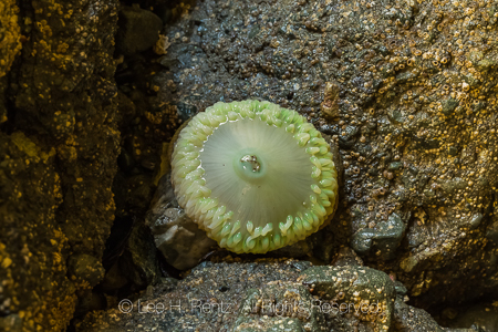
Giant Green Anemone, Anthopleura xanthogrammica, lacking algae in a dark microhabitat so it appears white, at Point of Arches
Orange Cup Coral, Balanophyllia elegans, in a tidepool at extreme low tide at Point of Arches
A feather-duster worm, aka fan-head worm: a plankton filter-feeder in the family Sabellidae, on rocky substrate at low tide at Point of Arches
Underwater view of Giant Green Anemone, Anthopleura xanthogrammica, at Point of Arches
Driftwood logs deposited during fierce winter storms on Shi Shi Beach
My bare feet on Shi Shi Beach
Dwarf Purple Olive, Olivella biplicata, shell probably occupied by a hermit crab, among Coralline Algae, at low tide at Point of Arches
Ochre Sea Star, Pisaster ochraceus, aka Purple Sea Star or Common Sea Star, at Point of Arches near mussel beds at low tide
Opalescent Nudibranch, Hermissenda crassicornis, in a tide pool at low tide at Point of Arches
Emarginate Dogwinkle, Nucella emarginata, aka Northern Striped Dogwinkle, Nucella ostrina, on the rocks deep inside the arches of Point of Arches
Shell and other body parts of a crab recently eaten by a Raccoon or River Otter (otters viewed, raccoon tracks seen nearby) at Point of Arches
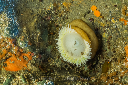
Giant Green Anemone, Anthopleura xanthogrammica, at Point of Arches
Giant Green Anemone, Anthopleura xanthogrammica, lacking algae in a dark microhabitat so it appears whitish, at Point of Arches
Mossy Chiton, Mopalia muscosa (L), and Hind’s Mopalia, Mopalia hindsii (R), at Point of Arches
Giant Green Anemone, Anthopleura xanthogrammica, with Pink Rock Crust, Lithothamnium pacificum (or related species), aka Encrusting Coral, at Point of Arches
Ochre Sea Star, Pisaster ochraceus, aka Purple Sea Star or Common Sea Star, with arms around an anemone, at Point of Arches near mussel beds at low tide
Ochre Sea Star, Pisaster ochraceus, aka Purple Sea Star or Common Sea Star, and Six-rayed Sea Star, Leptasterias hexactis, at Point of Arches near mussel beds at low tide
Man walking in the morning sea spray mist on Shi Shi Beach
Hikers and Point of Arches rocks at sunset
Feather Boa Kelp, Egregia menziesii, stranded and casting shadows on the sand of Shi Shi Beach
The rocks of Point of Arches nearing sunset
Pattern formed by water rushing back to the ocean as a wave recedes
Karen Rentz hiking on Shi Shi Beach
Columbian Black-tailed Deer, Odocoileus hemionus columbianus, near backpacking tent on Shi Shi Beach
An athletic young backpacking couple having fun on Shi Shi Beach
Black Oystercatcher, Haematopus bachmani, gathering at Willoughby Creek, a source of freshwater on Shi Shi Beach
Black Oystercatcher, Haematopus bachmani, at Willoughby Creek
Common Raven, Corvus corax, strutting on Shi Shi Beach
Northern Kelp Crabs, Pugettia producta, aka Spider Crab, in a tide pool with a lot of hermit crabs at Point of Arches
Frosted Nudibranch, Dirona albolineata, in a tide pool at Point of Arches
Smooth Bay Shrimp, Lissocrangon stylirostris, aka Sand Shrimp and Crangon stylirostris, found in tide pools at Point of Arches
Leather Star, Dermasterias imbricata, out of the water at low tide at Point of Arches
Red Crab, Cancer productus, in a tide pool at Point of Arches
Giant Green Anemone, Anthopleura xanthogrammica, with marks in sand where tentacles withdrew as tide went down
Striped Dogwinkle, Nucella emarginata, aka Emarginate Dogwinkle, with barnacles on rocky substrate at low tide at Point of Arches
Channeled Dogwinkle, Nucella canaliculata, laying eggs on rocky substrate at low tide at Point of Arches
Six-rayed Sea Star, Leptasterias hexactis, during an extreme low tide at Point of Arches
Black Turban, Tegula funebralis, aka Black Tegula, snails in a surge channel at Point of Arches
Giant Green Anemone, Anthopleura xanthogrammica, with Pink Rock Crust, Lithothamnium pacificum (or related species), aka Encrusting Coral, at Point of Arches
Karen Rentz inside a sea cave of Point of Arches at low tide
Rock formations with a large arch at Point of Arches at low tide
Rock formations with a large arch and photographer’s shadow at Point of Arches at low tide
Couple holding hands while walking on Shi Shi Beach
Rock formations of Point of Arches
California Beach Flea, Megalorchestia californiana, males fighting over a burrow near the high tide line on Shi Shi Beach
Point of Arches rocks at sunset
Point of Arches rocks at sunset
Point of Arches rocks at sunset
Rock formations of Point of Arches with a tide pool along Shi Shi Beach at low tide
Sandy shore ripples of Shi Shi Beach at low tide
Rock formations of Point of Arches with the sandy surface of Shi Shi Beach at low tide
Rock formations of Point of Arches with the rippled surface of Shi Shi Beach at low tide
Bull Kelp, Nereocystis luetkeana, stipe stranded and dried and casting curving shadows on Shi Shi Beach
Wooden pallet that has been at sea for a while, as evidenced by its load of large barnacles
By-the-wind Sailor, Velvella velvella, aka Sail Jellyfish, stranded on Shi Shi Beach
Wet sand on Shi Shi Beach after a wave subsided
Bull Kelp, Nereocystis luetkeana
Boardwalk along the trail through the Makah Reservation forest on the way to Shi Shi Beach
Traditional technique of removing strip of Western Redcedar, Thuja plicata, bark (for use in basketry and other crafts) from trees along the trail through the Makah Reservation on the way to Shi Shi Beach
If you want to visit Shi Shi Beach and Point of Arches, you need three permits:
Olympic National Park’s Wilderness Camping Permit. You can get this permit and a mandatory bear canister at Olympic National Park’s Wilderness Information Center at Port Angeles. The cost is $8 per person for overnight wilderness camping as of 2018.
Makah Nation’s Recreation Permit. As of 2018 this was a $10 per year hangtag for your car.
Parking Permit Bring cash of $10 per dayas of June 2018; this link also has great detailed information about the hike.
In addition, you really need to know how to read tide tables, both for safety and to get the most out of a coastal hike. Go to tides.net as a place to start, using the nearby Tatoosh Island and Cape Flattery tide charts. We prefer to explore tide pools when the tides are minus tides, such as -2.3 ft. or thereabouts. Read up on tides.
This is one of the premier nature hikes in North America: GO!
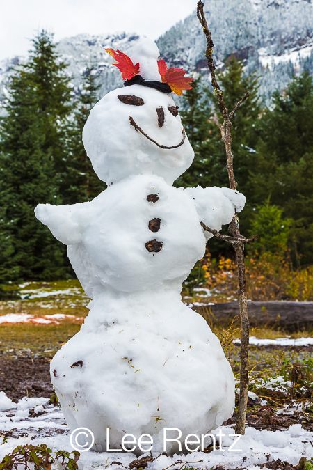
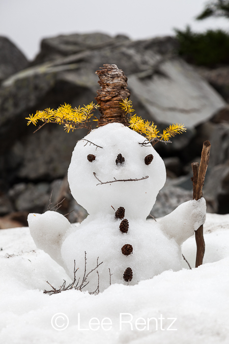
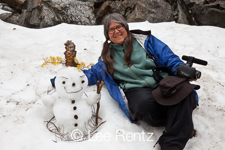
We were staying in a log hut during a Seattle Mountaineers trip to Mount Assiniboine Provincial Park, one of the dramatic high country huts in the Canadian Rockies, when it snowed one night. The next morning, Karen led an effort to create a snowman that reflected the changing seasons. It had a rain hat and a warm woolen scarf, as well as an evergreen mouth, a traditional carrot nose, and eyes of still-flowering purple asters that a Pack Rat had cut in front of our cabin. Making this “Hippy Chick” snowwoman took our minds off the Grizzly Bear tracks that were left overnight on the trail that went right by the hut.
The guy staying in the hut next to ours had been camping about a mile away, but a bear invaded his camp in the night and scared him, so he moved into the cabin. Perhaps our snowman worked as a talisman to ward off hungry grizzlies.
When backpackers unexpectedly encounter a group of, ahem, older hikers, making a snowman along a trail, they are delighted. After all, snowmen take us back to the days of carefree childhood, when playing in the snow was simply what we did in the winter, bundled up in snowsuits, woolen mittens, and warm boots. During those winter days of long ago, those of us growing up in northern climates would also make snow angels and erupt into spontaneous snowball fights–reflecting the sweet and agressive sides of our childhood natures.
Karen Rentz started creating snowmen during backpacking trips at least a decade ago. Gradually her friends came to expect that when they came to a remnant snowfield during a summer hike, they were going to be roped into making a snowman, and that it was a fun distraction from the exertion of hard hiking. Almost everyone pitched in, gathering hemlock cones and fallen lichens and twigs and leaves and whatever other natural materials were at hand, sometimes supplemented–long enough to take pictures–with mittens and hats.
These are sweet-tempered snowmen, unlike the snowmen that sprang from the mind of Bill Watterson’s Calvin in the Calvin and Hobbes comic strip (which I still miss): Calvin and Hobbes. Karen’s snowmen usually smile through a twig mouth and they have funny hats or hair and are gentle spirits, reflecting her soul.
All snowmen are ephemeral, of course, and that is part of their charm. When Karen and friends make a snowman, it some times lasts an hour or two, perhaps for another day or two, with sunshine and gravity taking their inevitable toll. But the short lives are okay, for none of us lasts all that long on this earth, and they are a reminder to stop and smell the roses: for that alone, making a snowman is worthwhile.
On Mount Townsend we built this snowman on the top edge of a very long snow slope that descended several thousand feet at a steep pitch, so we had to be careful not to slide off. On this spot once stood a U.S. Forest Service fire lookout cabin built in 1933 to watch for fires in Olympic National Forest, but it was destroyed in 1962.
This Mount Townsend snowman was born with a silver spoon in his mouth. We found the old spoon at the edge of the snow field, and believe that it was lost when the lookout cabin was destroyed. The eyes, nose, and buttons are made of small rocks that had been broken off the bedrock when water trickled into cracks in the rock, and then froze. These rocks originated millions of years ago on the Pacific Ocean floor, then were thrust up above the ocean to form the rugged Olympic Mountains. But enough of geology. The hair is made of fallen branches of Mountain Hemlock.
Karen Rentz with the Mount Townsend snowman. Cold knee!
While backpacking in The Enchantments of Washington State, there was a bit of remnant snow at the time the golden Alpine Larch needles were falling in October, so we gave this hula snowgirl a Hawaiian skirt, thinking about how much warmer it would be to be hiking in the islands.
There was just enough snow left over on that Enchantments hike to make a snowman’s head about the size of a big man’s fist; cones make up the eyes.
We built this snowman along the Pacific Crest Trail, at the very place we met a hiker who had already come all the way from Mexico and was going all the way to Canada. He was unique in that he was quite a dapper hiker, wearing a Panama hat, a neatly trimmed beard, and a necktie (really!); he said he was between jobs and wanted to be ready in case someone wanted to interview him for a job along the trail. Hey, I’d hire him for his sense of humor!
This Pacific Crest Trail snowman had pretty lupine flowers for hair, Mountain Hemlock cones for a nose and buttons, pine needles for eyebrows, and a happy twiggy smile. This snow field was located in the Goat Rocks Wilderness, a place where there once towered a volcano on the scale of Mount Rainier. It sits directly between Mount Rainier and Mount Adams in Gifford Pinchot National Forest, named for the founder of the national forest system who worked in Theodore Roosevelt’s administration.
Karen and I were driving through Yosemite National Park one fine autumn day and came upon a patch of snow that hadn’t yet melted from an early autumn snowfall. So, we just had to make this cute little snowman with Lodgepole Pine cone eyes. One of our photos of this snowman was featured in an article about quirky snowmen on NPR’s website several years ago.
We hiked with two friends around Gold Creek Pond in October of 2012, when the first heavy snows were starting to blanket the Cascade Mountains above Seattle. The last of the autumn leaves were still vivid, but the first major snow of winter had deposited enough snow to make a snowman. Gold Creek was also enjoying a Kokanee Salmon run, so while Karen did most of the work on the snowman, I did some underwater photography of the salmon, which were the color of burgundy. The underwater photography was so cool that I returned the next day to do some more. By then, the snowman was looking a bit under the weather, but I would be too if I had to stand in the same place all night. The second day, a young gold miner walked by and chatted with me (remember, this is GOLD Creek Pond); he carried some mining equipment–as well as having an exposed pistol on his belt. Mining is a serious activity, and that fall the price of gold was shooting upward, so a guy had to be prepared for outlaws.
We used vivid Vine Maple leaves for the hat, and Douglas Fir cones for the eyes. Gold Creek Pond is located near Snoqualmie Pass above Seattle in the Mount Baker–Snoqualmie National Forest.
Karen and I hiked up to Melakwa Lake at the end of July. It was a cold, foggy backpacking trip to one of the high mountain lakes located closest to Seattle, and at the beginning of the hike the trail leads under a beautiful elevated section of I-90 (it is elevated to allow avalanches to pass safely underneath). We created this handsome snowman, which we named “Misty Melakwa,” atop a remnant snow field. The hair is of a Mountain Hemlock branch that had turned yellow, perhaps after being buried for nine months under the snow, and the buttons and eyes are of hemlock cones. The spiky hat is a piece of old, weathered wood that might have been a hard knot from a rotted tree. “Misty Melakwa” has a bit of the devil in him, or so it looks from the crooked smile. Melakwa was an Indian word for “mosquito,” so we’re glad the weekend wasn’t warmer, allowing those pesky devils to swarm.
Karen Rentz with her creation. Our snowmen are not big, and they don’t live long.
Lee Rentz during one of his occasional beard phases (it would be much whiter today).
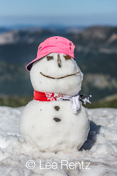
During a hike to Mount Fremont Lookout in Mount Rainier National Park in August, we started making a snowman a little ways off the trail on a remnant snow field. In this national park, the volunteer park rangers are adamant about staying on the trail, and we were several yards off the trail. I saw a ranger coming up the trail, and figured I would head her off at the pass by chatting with her about the trail. But she saw my comrades making the snowman and wondered what we were up to. I guess she figured that a group of older people making a snowman in late summer was a harmless, though slightly eccentric, activity so she let us off with a warning: “Please make sure you take a giant step onto the snow field to make sure you don’t crush any tiny plants about to emerge at the edge of the snow.” Duly noted. And done. (Though it should also be noted that a group of volunteer rangers was gathered off the trail around the lookout in lawn chairs, where they were having a party.)
With the lovely pink hat and fashionable scarf, this snow lady is definitely a girly-girl.
Karen, Joan, and Junko make up the trio of ladies who built this lovely creature.
A trail shelter at Boulder Camp in Olympic National Forest was our destination for this day hike. The trail shelter must have enjoyed divine intervention, because giant avalanches had frequently thundered down the surrounding mountains, but always seemed to miss the hut. We built this friendly snowman, with his carefully parted lichen hair, as a talisman to bring us good luck during our visit. He certainly looks friendly, and he is standing atop a tree that had been toppled by a long-ago avalanche.
Boulder Camp is located in the deep Upper Dungeness River Valley below Marmot and Buckhorn Passes in the Olympics. There aren’t very many of these shelters in Washington State’s mountains, but they do provide a dry place to get out of the rain when the weather takes a turn.
With hair and arms of Wolf Lichen, this snow woman is dancing atop a precarious snow bridge over a tiny creek. Wherever a creek flows under a snow field in the mountains, it melts the snow from underneath. Careless hikers can plunge through the thinned snow if they’re not careful, and that’s probably what happened to this little snowman after we left. RIP, tiny dancer!
A happy snowman made by Karen Rentz and Linda Moore along the Grassy Knoll trail in the Columbia River Gorge. Mount Hood points into the sky in the distance. His happy feet look to be made of Douglas Fir branches, with cones for toes.
Our most recent snowman, made in October high in The Enchantments above Horseshoe Lake, was in a meadow that still sported a few late summer wildflowers and lots of Pikas running around gathering winter hay in the meadows around the rocks. Pine hair and chartreuse lichen details make the snow guy look a bit crazy. This was created by Karen, Junko, and me.
Reason #1 for carrying an orange trowel is to scrape hardened snow off snowbanks in order to build a snowman. Reason #2 is, well, digging holes for #2. This happy hiker gal was enjoying the cool snows of summer in Mount Rainier National Park.
Made in Canada, this snowman features a fine rock hat, as well as nice rock body parts.
On Mount Rainier, even snowmen need ropes to climb the 14,410 foot high volcano, and this one has stylish ropes of red and purple.
The hat is made of layers and decorations of volcanic rock, while the scarf was made of flagging tape (removed before we left, of course). This was along the Skyline Trail near Paradise.
The Snowman Project will be continued, as long as there is snow to shape and trails to walk and bodies that can make the journey.
To see thousands of my photographs in large file sizes for use in magazines or other printed materials or electronic media, go to my NEW website at Lee Rentz Photography or go to my Flickr Photostream.
Yes, it was cramped. The five hour after Christmas flight from Detroit to Seattle was packed full, with not a seat to spare. There was a baby crying whenever we changed altitude, the audio wasn’t working on the plane’s channels, and the coffee maker was out of commission. At least I got two, count them, two little packets of pretzels!
The young woman next to me slept through four hours of the flight, but woke up brushing her leg when something wet and cold spilled on her (yes, I apologized for knocking over my water when I was trying to shift my cramped legs!). All in all, this was a typical flight these days, though we all have such low expectations that it really wasn’t that bad.
On the other hand, on this trip I selected a window seat so that I could look out at the passing landscape; and my wife took the window seat right in front of me, so that she could look out and also avoid having me spill a drink on her. I promised I wouldn’t kick her seat if she promised not to recline. So, we had a truce.
I slept through the takeoff, as I always do. My mother used to say that it wasn’t sleep at all–that I passed out because of a terror of flight, but I don’t think that is the case. There is something about the gentle vibration and noise of the jet engines that somehow reminds me of a lullaby, and I drift gently into the netherworld of dreams, awakening again only when I reach 36,000 feet, or my wife pokes me to say that the free pretzels have arrived. Or sometimes I awaken with an embarrassing loud snort that probably sends my seatmates into mental giggles, though they carefully avert their eyes.
On this flight we left the winter landscape of Michigan behind, and I woke up over Wisconsin or Minnesota, based upon the prairie landscape below. We were high above the clouds, which formed an intermittent flat layer far below, so it was only a thin layer of atmosphere between us and deep space, and only a thin layer of aluminum between our purported discomfort and the -60°F and 570 mph winds inches away.
It was an afternoon flight, and crystal clear. Sometimes there were gaps in the clouds and I could see the pattern of snow on hills and the straight scars of roads and the lake that was shaped like a snowman. Mostly it was just clouds, billowy and feathering far below. As we zoomed west, I started using my camera’s zoom to take pictures of the clouds and the Boeing 757’s wing. I like having the wing in my pictures, because it adds a graphic element that has scale and interest. Also, if it ever catches fire, I should be able to get a great photo of it!
Farther west, high above the northern plains and Rocky Mountains and sagebrush steppe, we sailed on. Clouds covered it all, but the clouds were putting on a great show as we chased the sunset. It started with a hint of gold in the clouds; then vivid orange as the sun sank below the horizon. Finally, at deep dusk the sky was the soothing blue of twilight, with purple clouds lighting up below, as if we were in a spacecraft orbiting Jupiter. It was spectacular.
Sailing over the Cascade Crest, I spotted two familiar landmarks: the cone of Mt. Adams, where we had hiked last Labor Day weekend, and Mt. Rainier, covered with a close-fitting garment of clouds. As we closed in on Seattle, we saw the lights of hundreds of cars crossing the floating bridges over Lake Washington and recognized roads and parks we had explored.
Mt. Adams and Mt. Rainier on the horizon
When we landed, I realized that I had taken well north of 100 photographs on this trip, and had spent most of the trip gazing out at the passing landscape. It reawakened my love of seeing the landscape from above, which is an astounding thing for a creature of Earth to see. This is as close as I will ever get to space travel, and it was wonderful.
To see my web site, which includes photographic prints for sale, please go to LeeRentz.com (just ask to email you a small version of a particular photograph you like if you can’t find it on the site; my website is not up to date).
To see thousands of my photographs in large file sizes for use in magazines or other printed materials or electronic media, go to my PhotoShelter Website or go to my Flickr Photostream.
The Seattle Great Wheel is a new 175 foot ferris wheel on the waterfront, giving people a new way to view the city, in addition to the iconic Space Needle. For a time it had frequent colorful, multi-colored light shows that lit up all the spokes of the wheel as it rotated. Neighbors in the waterfront apartments and condos complained about the bright lights of the Big Wheel, as if they had never heard of curtains, so now the light shows are just occasional. I photographed this from the ferry departing for Bremerton.
I recently devoted part of two spring days to photographing anything that caught my eye in Seattle, and I’ve included my favorites here. Some of the photos show tourist attractions that are also of interest to the natives, such as the famous Pike Place Market. Others are random signs or scenes that simply caught my eye or tell a story. Some of these are “classic” photographs I took over the last few years.
My philosophy of photography is simply to wander around in a zen state, open to anything that moves me or intrigues my photographer’s eye. Sometimes it is artistic, sometimes raunchy, sometimes funny, sometimes interesting to others.
Seattle is thought of as a city on the edge of technology and the new urban lifestyle, with its headquarters for Microsoft, Starbucks, and Amazon. Here is a retro vision of the city: the Seattle Steam Company, on the Seattle downtown waterfront, which looks like it just popped off the pages of a steam punk graphic novel.
Seattle has an activist mayor, Mike McGinn, who has long advocated bike lanes and routes in the city, giving him the moniker “Mayor McSchwinn,” though I believe he cheats by using a motorized bicycle. Here he is at the Pike Place Market for a news interview, dressed as casually as the rest of us in this city that takes “casual Friday” to “casual daily.” People who love fashion tend to hate Seattle!
We are green in oh so many ways, and little shared cars are the latest shade of green. Car2Go is a new venture by Daimler to provide flexible transportation to all the yuppies living in high-rise apartments and condos in the heart of the city. People can rent these little Smart Cars at 38 cents per minute, $13.99 per hour, or $72.99 for 24 hours. Just register for the service, find a car on your iPhone (they’re parked wherever people left them around the city), open the car lock somehow digitally, and take off. The company pays for gas. When you’re through, just park it in a legal spot along a city street. There are now something like 400 of these around the city; fortunately they don’t take much space.
Flying fish are a staple at the Pike Place Market. In this case a huge salmon is headed into the arms of a waiting fishmonger. These guys have such a sense of fun and teamwork that there are whole books about their philosophy; in fact, everyone on the fish team signed a book bought by a tourist at the stall while I watched. Just beware of the monkfish, which bit my nephew!
This is where they put Seattleites who don’t like coffee, rain, or liberal politics.
I love this sign, which is based on the Alfred Hitchcock movie starring Jimmy Stewart. It also reminds me of the opening sequence of Mad Men.
In the heart of the city, there is part of a city block devoted to a community garden, with lots of small plots for urban dwellers to grow vegetables and flowers–some to give to a food bank. This “Pea Patch,” as it is officially known, is located on extremely valuable land near the REI flagship store and the burgeoning offices of Amazon and biomedical research companies, and it is part of a system of Pea Patches throughout Seattle. The green space gives the eye a sense of relief from all the boring offices and condos.
Sometimes Seattle’s graffiti reminds me of my days in Ann Arbor, when students would do weird and cool stuff. Here the sign defacement apparently refers to a U2 song that I love (but I didn’t deface the sign; I would have done a neater job of it!).
Seattle’s Alaskan Way Viaduct, built in the early 1950s, is a relic of the past that still carries thousands upon thousands of vehicles on two levels along State Route 99 over the waterfront. Damaged in the 2001 Nisqually Earthquake (which also cracked the foundation of our house), the massive concrete viaduct is not long for this world. It is being replaced by a tunnel that is about to be bored. And, speaking of boring, the tunnel will not be as beautiful an experience as the viaduct, but it will open up the waterfront on Elliot Bay, making a much more pleasant experience for tourists and other pedestrians.
Jumbo Shipping brought the cutter for boring the new tunnel all the way from Osaka, Japan; here it is being unloaded on the waterfront. The boring machine, named Bertha, will dig a 57.5′ diameter wormhole under Seattle that will carry some of the traffic now carried by the viaduct. The problem is, there is going to be a toll on the tunnel, so notoriously skinflint Seattleites will skirt the tunnel, massively clogging the city streets. Such is urban planning in the land of the cheap.
Ah, the Dungeness Crab. Found in waters off the Washington and Oregon coasts, this ferocious looking beast is among the tastiest crabs anywhere. We sometimes get them and use a pair of nutcrackers and some cocktail stirrers to get at the meat inside the claws. For these dinners, Karen accuses me of making her work for her dinner. The crab, dipped in melted butter with a touch of lemon juice, is deep water heaven.
Beneath the waters of Puget Sound lives the biggest octopus in the world–far, far larger than this one–the Giant Octopus. Ferry boats and sailboats use special radar to avoid these octopuses, which can pull a boat down into the depths with two of their giant, suction-cupped arms. Or so the legend goes …
Urbane and sophisticated Seattle: the pink Elephant Car Wash stands near the shores of Lake Union, now the place where thousands of Amazon engineers write endless code to sell us stuff (I think most of their stuff is shipped to me!).
Until several years ago there was a trolley that ferried people back and forth along the waterfront, so that people didn’t have to walk to get a bowl of clam chowder at Ivar’s or see the shrunken heads and two-headed lamb at Ye Olde Curiosity Shop. The transportation department apparently didn’t get the memo that the trolley was permanently parked.
Beautiful morel mushrooms at $59.90 per pound–that’s immorel! Plus there are fern fiddleheads at $12.95 per pound, and multicolored carrots and hedgehog mushrooms and so much more at the Pike Place Market. Dine on the bleeding edge, if your bank account can stand it.
Even the shadows in Seattle are artistic. Some artist probably has a copyright on these shadows and will sue me for publishing them in my blog (Seattle has several artist/litigators who have sued the pants off photographers. Well, maybe not literally.)
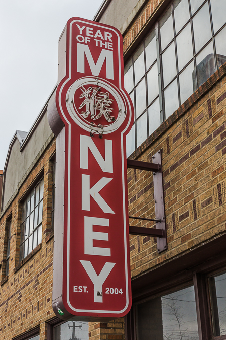
Love the name. Alas, the Year of the Monkey must be over, because construction workers were remodeling the building’s interior when I sauntered by. It had been a store featuring imported furniture and home accessories from Asia.
The Lusty Lady peep show was a downtown fixture for decades, and its marquee featured witty sayings. For example, when the Seattle Art Museum opened across the street, with its huge iconic sculpture “Hammering Man,” the marquee said “Hammer Away, Big Boy!” Alas, all good things cum to an end, and this was one of the last clever sayings. Internet porn apparently killed the desire for real porn.
This looks like one of those giant octopuses under Puget Sound, but it is an early warning floating radar system that is normally anchored off Alaska. I hope that, after repairs, it is now back in place monitoring North Korean incoming missiles. Mount Rainier stands in the distance, ready to blow up at the slightest provocation, much like North Korea.
Hat and Boots served as an iconic gas station for several decades, with the hat serving as the office and the boots as cowboys and cowgirls restrooms. Alas, the boots of progress stomped out this business, but the heroic citizens of Seattle rescued the Hat and Boots, like John Wayne rescuing the madam with a heart of gold, for use in a city park.
Enough of my silly pictures; this one from the Pike Place Market can melt the hearts of all the girls; after all, who doesn’t LOVE tulips and the coming of spring?
Big Wheel keep on toinin’ …
Alas, time to head back across the sound to where the little people live.
To see my web site, which includes photographic prints for sale, please go to LeeRentz.com (just ask me to email you a small version of a particular photograph you like if you can’t find it on the site; my website is not up to date)
To see thousands of my photographs in large file sizes for use in magazines or other printed materials or electronic media, go to my PhotoShelter Website.
This is part of a weblog documenting my travels and photography. I am primarily a nature photographer, and you can see more of my work athttp://www.leerentz.com
Sometimes a good church sign is just too funny for this photographer to pass up. In my recent travels in the American South, I encountered four church signs that made me laugh. One is intentionally funny; the others are based on quirky place names.
Click on the photographs below to see a larger version with captions.